Emma Matilda Lake Loop (via Two Ocean)
| Trail Features: | Panoramic Views, Wildlife, Fall Aspens | 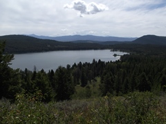 |
|||
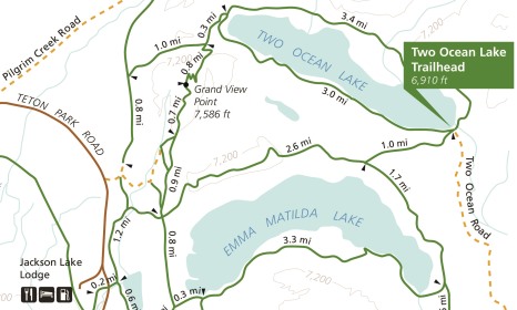
| Trail Location: | Two Ocean Lake Trailhead | ||||
| Roundtrip Length: | 11.0 Miles | ||||
| Trailhead Elevation: | 6910 Feet | ||||
| Total Elevation Gain: | 600 Feet | ||||
| Avg. Elev Gain / Mile: | 109 Feet | ||||
| Highest Elevation: | 7306 Feet | ||||
| Trail Difficulty Rating: | 12.20 (strenuous) | ||||
| Parking Lot Latitude | 43.90087 | ||||
| Parking Lot Longitude | -110.50205 | ||||
Trail Description:
This loop around Emma Matilda Lake in Grand Teton National Park begins from the Two Ocean Lake Trailhead. To reach the trailhead turn onto Pacific Creek Road, located roughly 0.9 miles north of Moran Junction. After driving roughly 2 miles, turn left onto Two Ocean Road and drive another 2.4 miles to the end of the gravel road. The hike begins from the far end of the parking area.
From the parking area hikers will immediately reach a split in the trail. For this hike description you should veer to the left and begin heading towards Emma Matilda Lake.
 Almost from the start the trail begins by traveling through a long stretch of thimbleberries, as well as several patches of high brush. Park officials make it quite clear that bears are present in this area. They emphasize that hikers should be alert, make noise, carry bear spray, and avoid hiking alone. In August of 1994 a jogger from Utah was attacked by a grizzly bear on the Emma Matilda Lake Trail. Although there have been six reported bear attacks in the park since 1994, none have been fatal.
In addition to bears there will be several opportunities for spotting a variety of wildlife as you proceed around the lake. As you travel the route you should keep an eye out for moose, elk, mule deer, coyotes, martens and osprey, in addition to waterfowl, such as common mergansers, common loons and trumpeter swans.
At just over one mile from the trailhead hikers will reach the loop portion of the hike. Although you can proceed in either direction, we chose to do this hike in a counter-clockwise direction because the views seem to be a little better along the northern leg of the Emma Matilda Lake Trail while proceeding in a westbound direction. Hikers, therefore, should turn right at this junction.
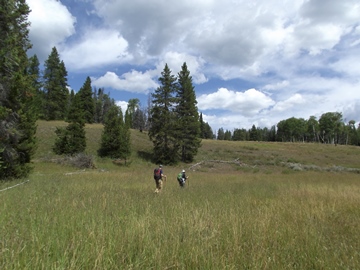
Just beyond the junction hikers will begin passing through a large grassy meadow. Soon you'll reach a couple aspen groves with some absolutely stunning views of the Grand Tetons in the background. If you're a budding photographer, this is an outstanding spot to possibly go home with some great fall aspen shots against the mountains.
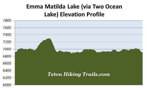
 At roughly 1.6 miles hikers will begin climbing a relatively steep ridge. As you approach the top of the bluff you'll enjoy some fantastic views of Emma Matilda Lake towards the southeast. This portion of the trail also passes through an area that was burned by a small wildfire in 1994.
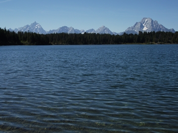
At roughly 3.6 miles hikers will arrive at a four-way junction. The trail leading to the right climbs to the summit of Grand View Point. This perch, roughly 1.7 miles from this junction, offers stunning views of the entire Teton Range. Proceeding straight ahead will lead hikers towards Jackson Lake Lodge. To continue on the loop you should turn left here.
This next segment of the loop travels between Emma Matilda Lake and Christian Pond. It also passes through large sagebrush meadows that offer a few glimpses of the Grand Tetons towards the west.
At roughly 4.5 miles hikers will reach a fork in the trail. The trail leading to the right effectively completes the eastern portion of the Christian Pond Loop, though a sign states that the trail is no longer maintained. The fork to the left continues the loop hike around Emma Matilda Lake. A short distance beyond this junction you'll reach the official junction for the Emma Matilda Lake and Christian Pond Loop trails. A hard right here would put you back on the Christian Pond Loop. To continue on the loop around Emma Matilda Lake hikers should bear to the left at this junction.
From the junction the trail enters the forest and begins heading towards the southern shore of Emma Matilda Lake. At just over 4.9 miles you'll reach another split in the trail. The right fork loops back to Jackson Lake Lodge. Hikers should proceed towards the left after crossing the small footbridge.
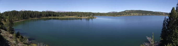
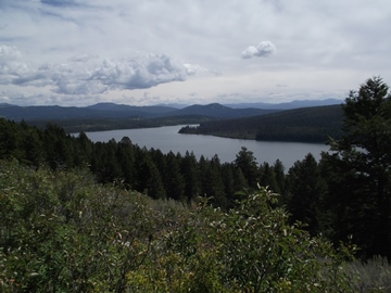
At roughly 5 miles hikers will reach Lookout Rock, a rock outcropping that stands roughly 30 feet above the water and offers commanding views of the western portions of Emma Matilda Lake. Rising above the trees on the far end of the lake is Mt. Moran and the northern Tetons. From this perch we watched a kingfisher hunt for a meal along the shoreline just below us. We also saw a few Canadian geese and common loons as well. No doubt, Lookout Rock is an outstanding place for an extended break.
Just beyond Lookout Rock you'll pass another side trail that leads back towards Jackson Lake Lodge.
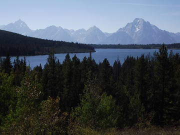
 At roughly 5.4 miles the trail begins traveling down a small hill. Soon you'll round a bend where you'll find a break in the canopy that offers an outstanding view of Grand Teton, Mt. Moran and the northern Tetons rising above Emma Matilda Lake. In case you're wondering, the lake was named for the wife of William O. Owen, organizer of the first ascent of Grand Teton in 1898.
From this vantage point the trail begins climbing away from the lake. The trail never really comes into contact with the lake again, and mostly stays within the confines of a dense forest. As you proceed further to the east you'll begin passing through a very long stretch of dead trees, the result of a lightning-ignited wildfire that burned roughly 100 acres in 1998.
At just over 8 miles the trail crosses over a footbridge, and soon begins making a wide arc around the eastern end of the lake. Keep an eye out for moose as you proceed through this area.
 At roughly 8.3 miles hikers will reach a trail junction in the middle of a grassy meadow that's surrounded by groves of aspen trees. A turn to the right will lead you to an unmarked trailhead on Pacific Creek Road. Hikers have the option of starting a similar loop from this trailhead, which would shorten your hike by roughly eight-tenths of a mile. To continue on towards the north side of Emma Matilda Lake hikers should turn left at this junction.
As the trail travels around the northeastern side of the lake it will pass through several grassy meadows. At first these meadows offer very little in the way of mountain views. However, once you arrive at roughly the 9.4-mile mark you'll have some really good views of the Grand Tetons rising above the lake towards the west.
At roughly 10 miles hikers will arrive at one last fork in the trail. The path leading towards the left continues along the north side of Emma Matilda Lake, while the trail to the right returns back to the Two Ocean Trailhead. From this point simply retrace your steps to return back to the trailhead.