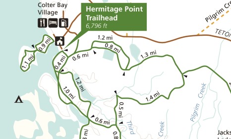
Heron Pond-Swan Lake Loop
| Trail Features: | Scenic Lake Views, Wildlife | 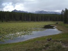 |
|||
| Trail Location: | Colter Bay (Hermitage Point Trailhead) | ||||
| Roundtrip Length: | 3.2 Miles | ||||
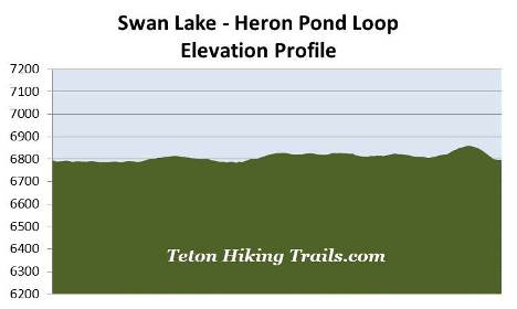
| Trailhead Elevation: | 6796 Feet | ||||
| Total Elevation Gain: | 115 Feet | ||||
| Avg. Elev Gain / Mile: | 72 Feet | ||||
| Highest Elevation: | 6860 Feet | ||||
| Trail Difficulty Rating: | 3.43 (easy) | ||||
| Parking Lot Latitude | 43.90115 | ||||
| Parking Lot Longitude | -110.64209 | ||||
Trail Description:
The Heron Pond and Swan Lake loop hike begins from the Hermitage Point Trailhead, located at the south end of the Colter Bay Visitor Center parking area in Grand Teton National Park. To reach the trailhead from Jackson Lake Junction drive 5.4 miles north and turn left onto Colter Bay Village Road. From the highway drive another nine-tenths of a mile towards the parking area near the visitor center. Once at the end of the road, turn left, away from visitor center, and proceed to the far end of the south parking area.
From the parking area hikers should follow the paved road that leads down towards the boat landing area where you'll see a sign that reads "Foot Trail Only - No Road." This marks the actual trailhead for the path leading towards Heron Pond and Swan Lake.
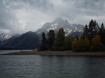 The hike begins by following an old service road that circles around the southern edge of the Colter Bay Marina. Almost immediately you'll enjoy some outstanding views of 12,605-foot Mt. Moran and 11,144-foot Rockchuck Peak towards the west.
At four-tenths of a mile from the trailhead hikers will reach the Swan Lake/Heron Pond split. Although you can continue in either direction, this hike description visits Heron Pond first, which means hikers should veer to the right at this junction.
From the junction the trail becomes a dirt footpath, and soon begins following along one of the coves in Colter Bay. Shortly thereafter you'll reach another junction. Though unmarked, you'll want to proceed towards the right to continue towards Heron Pond. The network of trails in this area of the park is a little more complicated than most. If you're unfamiliar with the area, it's probably a good idea to carry a detailed trail map.
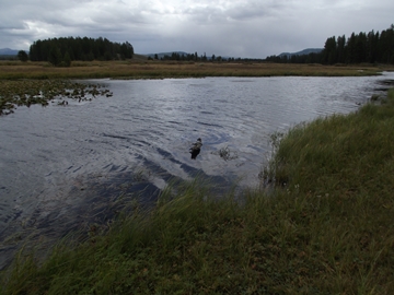
The Colter Bay area provides habitat for a wide variety of wildlife, including bear, moose, elk, mule deer, beaver, muskrat, river otters, sandhill cranes, trumpeter swans, ospreys, great blue herons, as well as snowshoe hares and martens.
The bay is named for John Colter, a key member of the Lewis and Clark expedition. Although evidence is inconclusive, Colter may have been the first Euro-American to visit the Grand Tetons. During the winter of 1807-08 Colter explored the greater Yellowstone area. His route, however, is uncertain. One theory holds that he traveled via Togwotee Pass. The other commonly held view traces Colter's route through Jackson Hole, over Teton Pass, and north along the west side of the Teton Range. No clear evidence exists to substantiate either route, only vague accounts and maps derived from interviews with Colter after his return. However, in 1933, an interesting stone was discovered near Tetonia, Idaho that may offer proof of the second theory. The stone has the name "John Colter" carved into it, and if authentic, would prove that Colter did travel the Teton Pass route. Unfortunately the Colter Stone has never been fully authenticated.
At seven-tenths of a mile hikers will reach a side trail that leads up to Jackson Lake Overlook, a perch that offers outstanding views of the Grand Tetons. This side trail reconnects with the main trail in six-tenths of a mile. To continue directly to Heron Pond hikers should veer to the left here.
At just over 1.1 miles hikers will pass the Jackson Lake Overlook trail once again. As you continue along this stretch of trail you'll likely notice the thick grassy undergrowth in this open lodgepole pine forest. Just beyond the junction is Heron Pond.
 After walking a short distance hikers will reach a short side trail that leads towards the water's edge. This lily-covered pond offers excellent habitat for a variety of wildlife, including great blue herons, various waterfowl and moose. You may even spot a beaver lodge or two along the shore.
As you proceed towards the southern shore of the pond you'll enjoy some great views of Mt. Moran and the northern Tetons along the way.
At almost 1.6 miles, as you approach the southern end of the pond, hikers will reach a junction that forms a narrow X. The trail leading towards the right takes hikers out to Hermitage Point. To continue on the loop hike, and begin heading towards Swan Lake, you should take a hard left here.
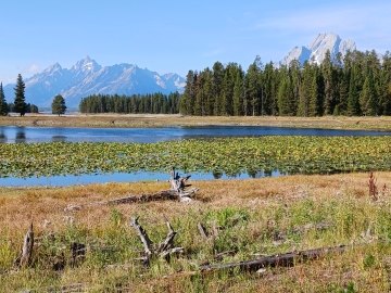
At just over 1.8 miles hikers will reach Swan Lake. This lake is also covered in pond lilies and grass, which gives it the appearance of being a large wetlands area, rather than a true lake. As you might expect from its name, this is a great place to possibly spot a trumpeter swan, among a variety of other waterfowl species.
 Trumpeter swans are the largest native waterfowl species in North America. They have wingspans up to 8 feet in width, and stand 4 feet high, but up to nearly 6 feet in height if the neck and legs are outstretched. Hunted for their plumage in the 19th and early 20th centuries, the swans nearly became extinct; however, conservation efforts have resulted in a rebound in some areas.
The trail continues along the edge of the lake for a very short distance, but turns to swing back into the forest. The footpath, however, eventually migrates back to the shoreline as it approaches the northwestern end of the lake. Hikers should also keep an eye out for moose near the lake.
At 2.8 miles hikers will reach another junction. Although you can proceed in either direction to return back to trailhead, this hike description follows the horse trail leading towards the right. This section of trail climbs over a small hill before returning back to the trailhead. Since there's really nothing of particular note to see along this segment, we recommend taking the left fork to return along the south side of the Colter Bay Marina.
For purposes of this hike description the trail reaches one last junction at roughly 3.1 miles. A turn to the right leads towards Cygnet Pond. Hikers should stay to the left here to continue back to the trailhead, which is a little more than a tenth-of-a-mile away.
Overall this is a great family hike, especially if you wish to possibly see some wildlife.