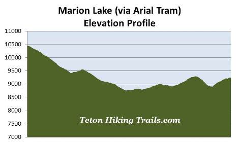
Marion Lake (via Arial Tram)
| Trail Features: | Panoramic Views, Lake, Wildflowers | 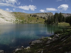 |
|||
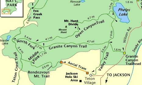
| Trail Location: | Aerial Tram - Teton Village | ||||
| Roundtrip Length: | 13.0 Miles | ||||
| Trailhead Elevation: | 10,450 Feet | ||||
| Total Elevation Gain: | 3560 Feet | ||||
| Avg. Elev Gain / Mile: | 548 Feet | ||||
| Highest Elevation: | 10,450 Feet | ||||
| Trail Difficulty Rating: | 20.12 (strenuous) | ||||
| Parking Lot Latitude | 43.58768 | ||||
| Parking Lot Longitude | -110.82764 | ||||
Trail Description:
This out and back hike to Marion Lake in Grand Teton National Park begins from the Jackson Hole Aerial Tram in Teton Village. Hikers will have to take the tram up to the summit of Rendezvous Mountain where the actual hiking begins, thus avoiding an additional 4139 feet of vertical climbing. A fee is charged for the 12-minute tram ride.
Although the loop version of this hike (which visits Marion Lake, but returns to Teton Village via Granite Canyon) is more than 3.5 miles longer than this out and back hike, it's actually slightly easier according to Paul Petzhold's difficulty rating formula used on this website. You may want to consider this option if you wish to explore more of the terrain in this section of the park.
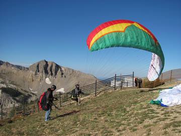 As you might expect, the views from the summit area are quite spectacular. You'll be able to see much of Jackson Hole, Jackson Lake, the Gros Ventre Mountains, as well as Grand Teton towards the north. 10,927-foot Rendezvous Peak will be the prominent mountain towards the southeast. You may even see a few paragliders taking off from the summit area.
After disembarking from the tram and soaking-in the stunning views, walk to the end of the platform and turn left to begin your hike. Hikers will then proceed down a steep gravel service road for just over four-tenths of a mile. The main service road makes a turn towards the left here, while another rough gravel road splits-off and continues straight ahead. Follow this side road as it traverses atop a ridgeline for roughly 0.15 miles, until reaching a sign that indicates the official start of the Rendezvous Mountain Trail. This will be the first trail sign since departing the tram that will indicate you're on the correct route.
Shortly after turning onto the Rendezvous Mountain Trail you'll pass a sign marking the Grand Teton National Park boundary. From here the trail descends rapidly through an evergreen forest, dropping almost a thousand feet in roughly eight-tenths of a mile.
At the bottom of the descent the trail immediately begins a moderate climb through fairly open terrain. After a short distance it levels out a bit where you'll likely notice a series of mountains off towards the north. The most prominent peak in this group is 10,783-foot Mt. Hunt.
The trail continues to pass through predominantly open terrain that offers sweeping views of the surrounding mountains. At roughly 3.7 miles hikers will reach the Middle Fork Cutoff Trail junction. The Rendezvous Mountain Trail continues along the right fork, which leads down into Granite Canyon. Hikers should turn left onto the Middle Fork Cutoff Trail to proceed towards Marion Lake.
From the junction the Middle Fork Cutoff Trail begins by traveling across flat terrain, but eventually becomes a mild grade as it approaches the Teton Crest Trail.
At just over 4.3 miles hikers will arrive at the Teton Crest Trail junction. A turn to the left would lead you up to Moose Creek Divide. To continue towards Marion Lake hikers should turn right here.
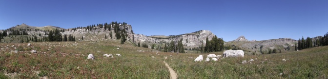
From the junction the Teton Crest Trail traverses along the upper portions of Granite Canyon. This segment of the route travels over some fairly steep terrain, while losing and gaining elevation twice along the way to Marion Lake. Fortunately this section of trail also travels through open terrain that offers sweeping views of the surrounding landscape. The upper canyon area is also known for its spectacular wildflower displays. Although most were pretty much spent, there were still quite a few varieties left during our early-September hike.
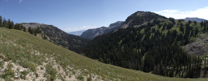
Soon the trail drops down to the Middle Fork of Granite Creek. After ascending the other side of the valley 10,537-foot Housetop Mountain will stand directly in front of you. The prominent mountain just to the right of Housetop is 10,031-foot Spearhead Peak.
Almost immediately the trail begins descending again, dropping rapidly into the North Fork of Granite Creek valley. Near the bottom, at roughly 5.9 miles, hikers will arrive at the Granite Canyon Trail junction. To continue towards Marion Lake hikers should proceed straight ahead. The lake is roughly six-tenths of a mile from this junction.
As you begin the final climb towards the lake you’ll enjoy some great views looking down Granite Canyon. You'll even be able to see Jackson Hole and the Gros Ventre Mountains in the far off distance.
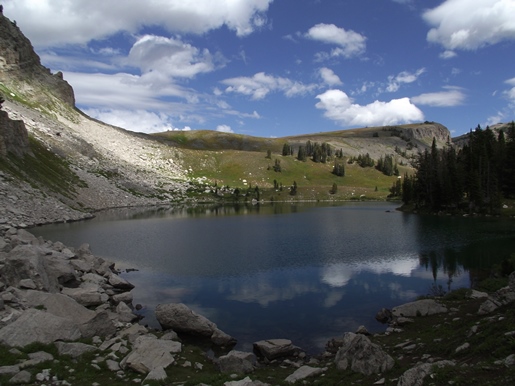
At just over 6.4 miles hikers will finally reach the top of the ridge, and shortly thereafter, will arrive at the southern shore of Marion Lake. This beautiful subalpine lake lies in a cirque basin below the summit of 10,537-foot Housetop Mountain. If you wish to see some alternate views of the surrounding terrain, the Teton Crest Trail continues to the eastern end of the lake. Also, just east of the lake is another large meadow that offers spectacular wildflower displays. Arguably one of the best times to visit this area is in late July when the wildflowers are at peak bloom.
Hikers should note that snow can sometimes linger in this area until late July. Early season hikers should check with a ranger on conditions before deciding to hike this trail.
On your return trip back to the aerial tram you'll have the option of taking a slightly different route back. This will involve turning left onto the Granite Canyon Trail and proceeding down to the Rendezvous Mountain Trail junction. Here you'll take a right to travel back up to the Middle Fork Cutoff Trail / Rendezvous Mountain Trail junction. In addition to having the opportunity to explore a little more of the area, this option will add roughly one-half mile and another 250 feet of climbing to your overall hike.
No matter which route you take, hikers should always be aware of lightning risk while hiking in the Grand Tetons, especially at higher elevations. As a general rule of thumb you should plan to turnaround before noon in order to avoid the notorious afternoon thunderstorms that frequent the mountains during the summer months. Hikers should also be prepared for extreme sun exposure, wind, cool temperatures, and rapidly changing weather conditions while on the trail. Make sure you have the proper gear with you, and know what safety precautions you need to consider beforehand.