Signal Mountain
| Trail Features: | Panoramic Views, Wildlife, History | 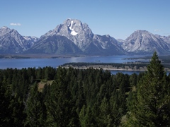 |
|||
| Trail Location: | Signal Mountain Lodge | ||||
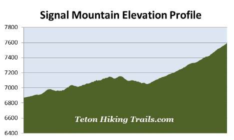
| Roundtrip Length: | 6.8 Miles | ||||
| Trailhead Elevation: | 6870 Feet | ||||
| Total Elevation Gain: | 920 Feet | ||||
| Avg. Elev Gain / Mile: | 271 Feet | ||||
| Highest Elevation: | 7593 Feet | ||||
| Trail Difficulty Rating: | 8.64 (moderate) | ||||
| Parking Lot Latitude | 43.84293 | ||||
| Parking Lot Longitude | -110.61104 | ||||
Trail Description:
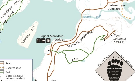
The hike to Signal Mountain in Grand Teton National Park begins from the Signal Mountain Lodge parking area. The lodge is located 3 miles south of Jackson Lake Junction, and 17.6 miles north of Moose Junction.
After turning into the Signal Mountain Lodge area you should turn right into the main parking area. The trailhead is located on the opposite side of the entrance road. To reach the trailhead from the parking area you can either walk westbound along the road, passing the general store and the campground registration area, or take the unmarked paved path located just to the east of the campground registration area. The trailhead itself is located almost directly across from the employee housing area.
 To me there's something about earning a scenic view that makes them so much more enjoyable. Although you can drive a vehicle along the paved road to the top of Signal Mountain, taking the hiking trail is far more rewarding, as it allows you to slowly soak in all the sights as you proceed higher.
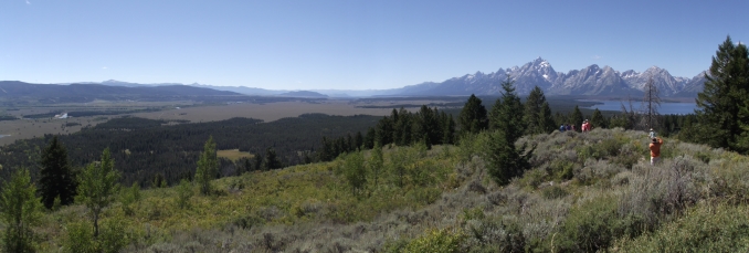
Although the trail doesn't go all the way to the summit of the 7720-foot mountain, it does offer outstanding panoramic views of the Grand Tetons, Jackson Lake and the Snake River from a vantage point known as Jackson Point Overlook.
The actual trailhead for this hike is located roughly two-tenths of a mile from the parking area. Soon after turning onto the trail hikers will cross over Teton Park Road. The trail then makes a relatively steep climb up to Signal Mountain Road, and crosses over it at almost the half-mile mark from the parking area.
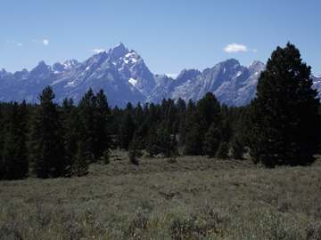
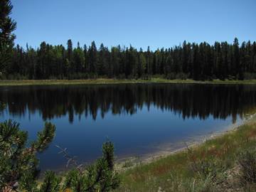
A short distance beyond the road the trail passes a pleasant lily pond. Keep an eye out for moose here. Although much of the early portions of the hike remain under the canopy of a conifer forest, hikers will have an excellent view of Mt. Moran at roughly two-thirds of a mile.
 At just over seven-tenths of a mile hikers will arrive at a fork in the trail, which marks the beginning of the short loop portion of the hike. Although you can take either direction, I highly recommend taking the right fork (Lake Trail) on the way up, and then return on the opposite side on your way back down. This way you'll have some great views of the Grand Tetons while descending along the north side of the loop (Ridge Trail) on your return trip. Although the southern half of the loop is more wooded, it does visit a pleasant lake along the way.
As the southern loop meanders past the small lake, hikers will have the opportunity of spotting a variety of wildlife. Look for moose, black bears, mule deer, as well as ducks and other waterfowl. Although two-tenths of a mile longer, this portion of the loop is basically flat, with a slight climb towards the end.
On your return trip the northern loop will have a few more ups and downs. The terrain along this section of trail, however, is far more open, and passes through a fairly large sagebrush meadow that offers sweeping views of the Grand Tetons. Both options will offer a plethora of wildflowers in the early-to-mid summer time period.
 At almost 2.2 miles hikers will reach the upper junction, thus ending the loop portion of the hike on the way up. From this point forward the trail resumes a moderately steep climb, while alternating between lodgepole pine forest and grassy meadows.
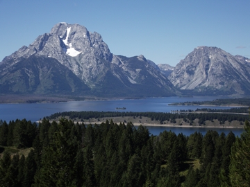
At roughly 3.5 miles hikers will finally reach Jackson Point Overlook. This perch offers some absolutely stunning views of the Grand Tetons, Jackson Lake, Jackson Hole and the Gros Ventre Mountains. In addition to the outstanding views, keep an eye out for large birds of prey, such as golden eagles and red-tailed hawks, gliding on the warm thermals.
Although you might conclude that the name for Jackson Point Overlook comes from the fact that you'll have commanding views of Jackson Lake and Jackson Hole from this vantage point, it's actually named after William Henry Jackson. As part of the 1871 Hayden Geological Survey expedition, William Henry Jackson took the first photographs of the Grand Tetons from the west side of the range. During the 1878 Hayden Geological Survey, Jackson took the first photos from Jackson Hole, including the first photos from this spot that now bears his name.
The mountain itself received its name as a result of a suspicious death. John Dudley Sargent, along with his partner, Robert Ray Hamilton, a great-grandson of Alexander Hamilton, ran the nearby Merymere Lodge which overlooked Jackson Lake. In August of 1890 Hamilton went missing during a hunting trip. Search parties were organized with instructions to light a "signal" fire atop the mountain when he was found. A week later his body was found floating in the Snake River. Speculation swirled as to whether he was murdered by his business partner, who was also suspected of murdering his wife several years later.
My book, Ramble On (a history of hiking), contains an extensive section on the development of trails and hiking culture in America's first tourist destinations, national forests and national parks.