Alaska Basin (Basin Lakes)
| Trail Features: | Panoramic Views, Alpine Lakes, Wildflowers | 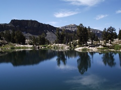 |
|||
| Trail Location: | Teton Canyon (South Teton Trailhead) | ||||
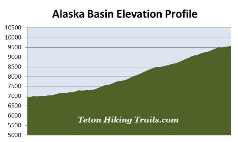
| Roundtrip Length: | 16.6 Miles | ||||
| Trailhead Elevation: | 6950 Feet | ||||
| Total Elevation Gain: | 2635 Feet | ||||
| Avg. Elev Gain / Mile: | 317 Feet | ||||
| Highest Elevation: | 9568 Feet | ||||
| Trail Difficulty Rating: | 21.87 (strenuous) | ||||
| Parking Lot Latitude | 43.75563 | ||||
| Parking Lot Longitude | -110.91545 | ||||
Trail Description:
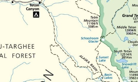
The hike to Basin Lakes in the Alaska Basin begins from Teton Canyon on the west side of Grand Teton National Park. From Highway 33 in the heart of Driggs, ID, turn eastbound onto Ski Hill Road. At just over a mile you'll reach a fork in the road. Bear left here and continue on Ski Hill Road, heading towards Grand Targhee Resort. Roughly 4 miles from Highway 33 you'll reach the Wyoming state line, and will soon pass through the town of Alta. At roughly 6.4 miles you'll reach the Targhee National Forest boundary. At 6.6 miles, just after crossing over the cattle guard, turn right onto Teton Canyon Road, which soon turns into a gravel road. From the junction drive another 4.6 miles to the South Teton Canyon Trailhead, located at the end of the road. While Teton Canyon Road is a gravel road with lots of pot holes and washboard, two-wheel drive vehicles shouldn’t have any problems, as long as you take your time.
The Alaska Basin Trail begins by passing through a pleasant evergreen forest. Just beyond the trailhead hikers will enter the Jedediah Smith Wilderness in the Caribou-Targhee National Forest. From this point forward the trail stays within the confines of the wilderness, and never enters Grand Teton National Park.
As the trail proceeds up Teton Canyon it begins climbing a mild grade while passing through a few aspen groves, as well as some long stretches of high brush. This is a good place to make a lot of noise to warn any bears that might be around that you're passing through their territory. You should also keep an eye out for moose in and around the willow-choked creek on your left. Much of this hike follows along the South Fork Teton Creek.
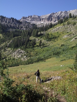
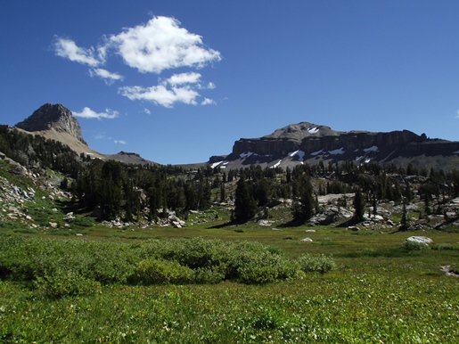
A little more than 1.5 miles from the trailhead the valley opens up. Here you'll enjoy great views of The Wedge, Mt. Jedediah Smith and Mt. Meek almost directly straight ahead.
At just over 2.8 miles hikers will arrive at the Teton Shelf Trail, which branches off to the right and heads towards Devils Stairs, located roughly nine-tenths of a mile away. To continue towards Alaska Basin hikers should veer to the left at this junction.
Depending on the season, or recent weather patterns, there may be several sections of trail that are fairly muddy. Since much of the trail is shared with horses it can make for some pretty rough and/or mucky conditions.
Above the Teton Shelf Trail junction the route travels through mostly wooded terrain along a moderate grade. However, at roughly the 5.1-mile mark, the trail begins traveling through open country where the terrain becomes a little steeper.
At roughly 5.8 miles hikers will reach a short section of trail that traverses across bare rock. For a very brief moment the trail may be a little difficult to follow. Keep an eye out for a few cairns, stay towards the bottom of the bare rock area, and you shouldn't have any problems picking-up the trail on the other side.
Roughly 6.4 miles from the trailhead the footpath reaches a large meadow where you'll enjoy magnificent views of Mt. Meek and The Wedge. Beyond this point the trail becomes quite rocky and rugged, while passing through intermittent groves of trees and meadows. Hikers will also find large boulders, more bare rock areas, and a few waterfalls. The trail also crosses over several creeks without the aid of a footbridge where some rock hopping is involved. Some of the crossings are fairly narrow, while others are wider where you'll have to watch for a few loose stepping stones. Hikers may want to consider bringing trekking poles to assist with balance during these crossings.
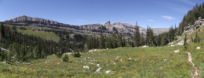
At just over 7.7 miles hikers will finally reach the top of the climb and enter the Alaska Basin zone. 11,938-foot Buck Mountain will be the prominent peak looking straight ahead from this vantage point.
A short distance later, at just over 7.8 miles, hikers will arrive at the Teton Crest Trail junction. A turn to the left would lead you towards Sunset Lake. To continue towards Basin Lakes you should turn right here.
Nearly 8 miles from the trailhead the Teton Crest Trail splits off toward the right. Hikers should take the left fork to continue towards Basin Lakes and Mirror Lake. As you might expect the scenery in and around this high alpine basin is absolutely stunning.
From the junction the trail traverses around and between a series of small ponds. At roughly 8.3 miles you'll finally reach Mirror Lake, the largest of the Basin Lakes. From its eastern shore the views of Mt. Meek and the surrounding mountains are quite spectacular.
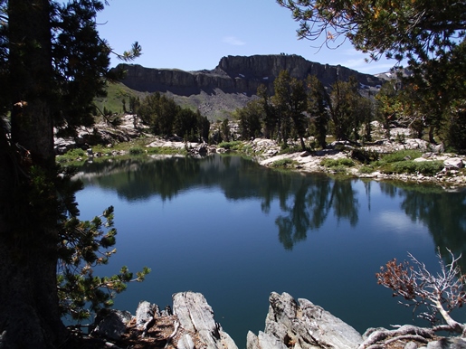
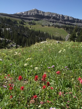
By far, this is the best day hike in the Grand Tetons for alpine meadows and scenery. The basin is known for its exceptional wildflower displays in late July and early August. Even during our early September hike there were still quite a few varieties left. Depending on your location within the basin, Battleship Mountain, Veiled Peak, Buck Mountain and Mt. Meek are all visible from various spots.
Hikers should note that the entire route passes through prime bear habitat, so you should be alert, travel in groups of three or more, carry bear spray, and make a lot of noise.
Hikers should always be aware of lightning risk while hiking in the Grand Tetons, especially at higher elevations. As a general rule of thumb you should plan to turnaround before noon in order to avoid the notorious afternoon thunderstorms that frequent the mountains during the summer months. Hikers should also be prepared for extreme sun exposure, wind, cool temperatures, and rapidly changing weather conditions while on the trail. Make sure you have the proper gear with you, and know what safety precautions you need to consider beforehand.