Bunsen Peak - Osprey Falls Loop
| Trail Features: | Outstanding Views, Waterfalls, Wildlife | 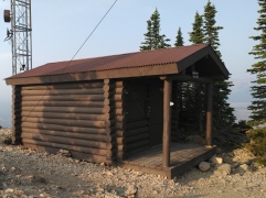 |
|||
| Trail Location: | Mammoth | ||||
| Roundtrip Length: | 10.1 Miles | ||||
| Trailhead Elevation: | 7278 Feet | ||||
| Total Elevation Gain: | 2160 Feet | ||||
| Avg. Elev Gain / Mile: | 428 Feet | ||||
| Highest Elevation: | 8564 Feet | ||||
| Trail Difficulty Rating: | 14.42 (strenuous) | ||||
| Parking Lot Latitude | 44.93216 | ||||
| Parking Lot Longitude | -110.72783 | ||||
Trail Description:
The Bunsen Peak - Osprey Falls Loop hike begins from the Bunsen Peak Trailhead, located roughly 5 miles south of Mammoth on Grand Loop Road in Yellowstone National Park. Look for a gravel parking lot on the east side of the road, just south of Golden Gate.
In order to beat the crowds we arrived at the trailhead at the break of dawn. As a result, we were treated to the sound of wolves howling from three different directions as we prepared for our hike. At the same time we could hear at least one bull elk bugling near the base of the peak. The bugling could be heard all the while we ascended the mountain, as well as at the summit.
Hikers should note that the park website warns that grizzly bears are known to frequent this area. Thus, it’s a good idea to hike in groups of at least three, make lots of noise, and carry bear spray on this hike.
Although you can proceed in either direction, we chose to climb the mountain first in order to avoid climbing during the heat of the day. Moreover, if you were to visit Osprey Falls first, you would have to climb out of the canyon, and then almost immediately begin climbing the mountain.
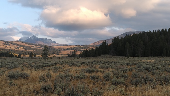
Almost immediately the trail begins to climb, and at just under a mile from the parking lot it begins to ascend the mountain itself. As you proceed higher you’ll begin ascending a series of short switchbacks along the northwestern and northern slopes of the mountain. From the trailhead to the summit the path meanders in and out of forested areas. While passing through open areas hikers will enjoy great views of Swan Lake Flats and the Gallatin Mountain Range towards the west, as well the Golden Gate and Mammoth Hot Springs areas towards the north. Though there are some steep sections along the route, the climb is moderately strenuous, with virtually no exposure to any steep drop-offs.
At roughly 2.1 miles hikers will reach the radio cabin atop the peak. Also located here are antennas and other communication equipment that serve Mammoth and other nearby communities. Though you may think you’ve reached the highest point on the mountain, this is technically a false summit. The true summit is located another tenth-of-a-mile towards the south. Here you’ll find four concrete tower footings. These likely supported a fire lookout that once stood atop the mountain in the mid-1900s, and was possibly constructed around 1940, according to a Salt Lake Tribune article. Although there’s very little information available on the internet, it appears that the lookout stood atop the peak until at least 1957. One photo I found shows it to be a low wooden structure, resting on four concrete footings.
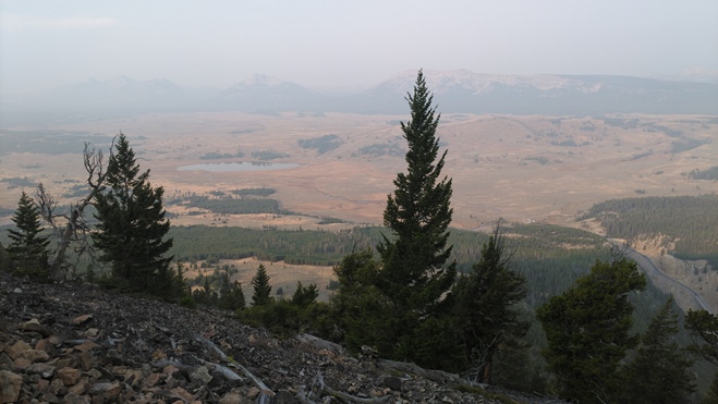
Although there are quite a few trees at the summit, you’ll still enjoy panoramic views of the surrounding area. In addition to Swan Lake Flats and the Gallatin Mountains towards the west, hikers will also enjoy birds-eye views of Blacktail Deer Plateau and the Yellowstone River Valley towards the east.
From a geological standpoint, Bunsen Peak is an ancient volcanic cone. Fittingly, the mountain is named for Robert Bunsen, a German chemist who studied volcanic activity in Iceland during the mid-1800s, and became famous as the inventor of the Bunsen Burner. The first documented ascent of the peak was made by Ferdinand V. Hayden and Captain John W. Barlow during the first Hayden Geologic Survey in 1871.
From the summit the trail continues by descending along the eastern slopes of the peak. After roughly one-half mile or so you’ll begin passing through a large swathe of forest that was burned during the North Fork Fire of 1988. In all, the infamous fires during that summer burned almost 794,000 acres in Yellowstone, or roughly 36% of the entire park. Much of the area surrounding the mountain was burned that year.
At roughly 4.25 you’ll notice that the trail approaches Bunsen Peak Road, but doesn’t actually come in contact with it. The two trails will intersect at a junction roughly one tenth-of-mile further down the path. Located at this same junction is the Osprey Falls Trail. Interestingly, the park has installed a large sign here that reads: “Caution: Trail Is Steep And Narrow, Travel At Your Own Risk”. This is probably something they should’ve posted at the trailhead to provide hikers with this warning ahead of time. The trail is indeed fairly steep and narrow, so if you have a fear of heights you may want to find another hike, especially if the ground is wet. I would definitely recommend bringing trekking poles to help with your footing and balance as you proceed down the canyon. If you take your time you shouldn’t have any problems.
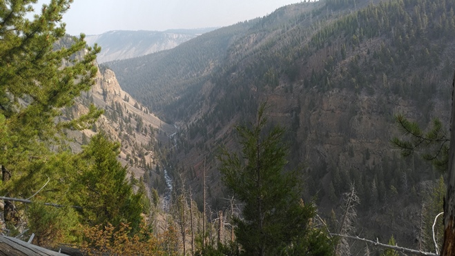
 Almost immediately after turning onto the Osprey Falls Trail you’ll begin to hear the roar of the Gardner River at the bottom of the deep canyon. Over the course of the first half-mile the trail travels along the rim of Sheepeater Canyon, before turning east to begin its sharp descent down to the bottom of the canyon. As we descended we spotted a family of mountain goats scaling the cliffs on the opposite wall. Historically, it’s believed that mountain goats aren’t native to Yellowstone, and that a population migrated into the park in the 1990s.
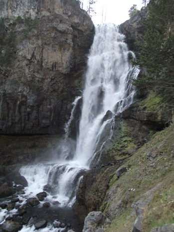
From the rim the trail drops more than 600 feet along a series of switchbacks to reach the floor of the canyon. Take your time as you descend to admire the stunning beauty of this rugged canyon. At almost 5.6 miles hikers will reach Osprey Falls, an absolutely spectacular waterfall that drops roughly 150 feet, making it one of the tallest falls in the park. This impressive waterfall and canyon struck me as a smaller version of the Grand Canyon of the Yellowstone - without the crowds.
To complete the loop you’ll have to retrace your steps back up to the canyon rim. Once back at the Osprey Falls Trail junction, turn left onto Bunsen Peak Road to return to the trailhead. The trail, or road, skirts around the southern slopes of Bunsen Peak, much of it on flat terrain. Most of this route travels through open country where you’ll enjoy panoramic views of the surrounding meadows and mountains. The road also serves as a mountain biking route.
At roughly 8.1 miles the trail travels past an overlook that provides great views of the Gardner River valley as it heads towards Sheepeater Cliffs. From this point the trailhead is located roughly two miles away.
Additional Resources:
* Yellowstone National Park website
* Trail Map (trails are not included on the official park map)
* Lonely Planet Yellowstone & Grand Teton National Parks