Forks of Cascade Canyon
| Trail Features: | Panoramic Views, Waterfall, Wildlife | 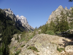 |
|||
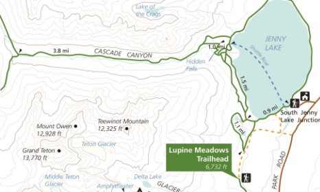
| Trail Location: | Jenny Lake Trailhead | ||||
| Roundtrip Length: | 10.0 Miles | ||||
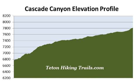
| Trailhead Elevation: | 6783 Feet | ||||
| Total Elevation Gain: | 1110 Feet | ||||
| Avg. Elev Gain / Mile: | 222 Feet | ||||
| Highest Elevation: | 7820 Feet | ||||
| Trail Difficulty Rating: | 12.22 (strenuous) | ||||
| Parking Lot Latitude | 43.75114 | ||||
| Parking Lot Longitude | -110.7238 | ||||
Trail Description:
The hike to the Forks of Cascade Canyon in Grand Teton National Park begins from the Jenny Lake Trailhead. To reach the trailhead turn west off Teton Park Road at the South Jenny Lake Junction, located roughly 7.7 miles north of Moose Junction. From the junction drive another half-mile to the boat dock parking area. Hikers will have the option of walking around the south end of Jenny Lake, or taking the shuttle boat across the lake to the Cascade Canyon Trailhead. The boat cuts-off roughly 2.4 miles of walking each way; however, there's a fee for the boat ride.
This hike description follows the route beginning from the Cascade Canyon Trailhead, located at the West Shore Boat Dock, after taking the 12-minute shuttle boat across Jenny Lake.
Covering roughly 1191 acres, glacially-carved Jenny Lake is the second largest lake in the Grand Tetons. At 423 feet it's also one of the deepest. The lake was named for a Shoshone Indian named Jenny who assisted with camp logistics during the Hayden Geological Survey of 1872. Nearby Leigh Lake is named for her husband, Richard "Beaver Dick" Leigh, an itinerant trapper and early tour guide who helped guide the Hayden Expedition through this region. In 1876 Jenny and their six children died of smallpox.
From the boat dock the trail begins climbing upward through a pristine conifer forest. It's likely you'll notice quite a few huckleberry patches along this stretch, which is one of the reasons why you'll need to watch for bears on this hike.
Soon the trail crosses Cascade Canyon Creek, and at roughly three-tenths of a mile will reach the Valley Trail, which also serves as the western portion of the loop hike around Jenny Lake.
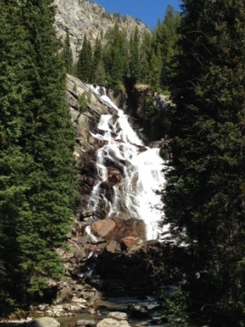
At just over a half-mile from the boat dock you'll pass the horse trail leading up from Jenny Lake. A short distance later you'll arrive at the side trail that leads to Hidden Falls. Hikers should turn left here to visit the viewing area of this impressive waterfall. Situated near the mouth of Cascade Canyon, Hidden Falls drops roughly one hundred feet in a series of steps.
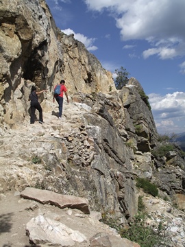
After viewing the waterfall return back to the main trail and turn left to continue towards Inspiration Point. From the falls the trail resumes climbing along a very rocky and rugged footpath. As you near Inspiration Point you'll pass over a short section of trail that traverses a fairly steep ledge. This granite-carved segment of trail that gains access to Inspiration Point was built by Civilian Conservation Corps workers in the 1930s. Hikers should definitely use caution along this stretch.
As you climb higher you'll enjoy outstanding views of the "Cathedral Group" towering above the canyon towards the west. This group of mountains includes 12,325-foot Teewinot Mountain, 13,770-foot Grand Teton and 12,928-foot Mt. Owen.
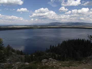 At 1.1 miles hikers will reach Inspiration Point, one of the most popular hiking destinations in the national park. From this lofty perch you'll enjoy commanding views of Jenny Lake, Jackson Hole, as well as the Gros Ventre Mountains towards the east. For those wishing to go home with some great photos, the sun will likely pose problems during the morning hours. If you're headed towards destinations further up the canyon you're much more likely to have better photo opportunities of the lake on your return trip.
From this popular vantage point the trail continues towards the west. Fortunately the elevation gain becomes much more gradual as well. Soon hikers will enter the mouth of Cascade Canyon, and at almost 1.5 miles from the trailhead, will pass the north horse trail junction. Hikers should proceed straight ahead here.
Over the course of the first couple of miles the trail passes through numerous huckleberry, thimbleberry and wild raspberry patches. While passing through these areas it's a good idea to make a lot of noise in case there are any bears around, especially near Cascade Canyon Creek where bears may not be able to hear your approach. While black bears are frequently seen in Cascade Canyon, grizzly bears are becoming more common. Therefore, it's a good idea to carry bear spray, make lots of noise, and travel in groups of three or more while hiking this trail.
 As you proceed the canyon begins to narrow, and at roughly 1.9 miles you'll reach the first in a series of large boulder fields resting along the southern slopes of Storm Point. Keep an eye out for picas and marmots as you pass through these areas. Also keep an eye out for moose near the willow-choked creek on your left. The views of Mt. Owen, the prominent mountain on the south side of the canyon, are absolutely stunning throughout this area. At 12,928 feet Mt. Owen is the second highest mountain in Grand Teton National Park, and is named for William O. Owen, organizer of the first ascent of Grand Teton in 1898.
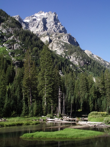
At roughly 2.6 miles you'll reach a series of ponds that make excellent foregrounds for the looming mountains above. You may also want to keep an eye out for harlequin ducks and common mergansers, both of which are frequently spotted in these shallow waters.
As you proceed further into the canyon, 11,106-foot Table Mountain and 10,840-foot The Wigwams will come into view towards the west. These two mountains help to form the western boundary of Cascade Canyon. As the trail proceeds even deeper into the canyon you'll also likely notice that it begins passing through areas that are considerably more forested.
At 5 miles hikers will finally reach the Forks of Cascade Canyon, which represents the end point for this hike. Hikers with the time and energy have the option of continuing beyond the "Forks". The trail to the left leads towards Hurricane Pass and Alaska Basin, while the trail to the right heads up the North Fork of Cascade Canyon, and eventually on to Lake Solitude.