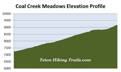
Coal Creek Meadows
| Trail Features: | Outstanding Panoramic Views, Wildflowers | 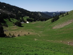 |
|||
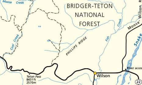
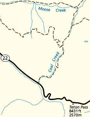
| Trail Location: | Coal Creek Trailhead | ||||
| Roundtrip Length: | 5.7 Miles | ||||
| Trailhead Elevation: | 7250 Feet | ||||
| Total Elevation Gain: | 1970 Feet | ||||
| Avg. Elev Gain / Mile: | 691 Feet | ||||
| Highest Elevation: | 9185 Feet | ||||
| Trail Difficulty Rating: | 9.64 (moderate) | ||||
| Parking Lot Latitude | 43.51076 | ||||
| Parking Lot Longitude | -110.98579 | ||||
Trail Description:
The hike to Coal Creek Meadows and Coal-Mesquite Divide begins from the Coal Creek Trailhead, located west of Teton Pass on WY 22. The trailhead is located just off the highway, roughly 9.1 miles east of Victor, ID and 9.7 miles west of Wilson, WY.
 Although you'll enjoy outstanding views from upper Coal Creek Meadows, this hike description travels just beyond the meadows to the top of Coal-Mesquite Divide where you'll enjoy some rather dramatic views of the Mesquite Creek Valley and the mountains towards the north, including Grand Teton.
Although the trailhead sign seems to indicate that the trail proceeds straight up the hill, you'll reach a stream crossing without the benefit of a footbridge after a very short distance. Your best bet is to go to the west side of the parking lot and cross over the footbridge almost immediately next to the parking lot, and then proceed up the west side of Coal Creek.
After walking almost a quarter-of-a-mile you'll link up with the main trail, and shortly thereafter, will reach the Jedidiah Smith Wilderness boundary. Located entirely within the Caribou-Targhee National Forest, the Jedediah Smith Wilderness was originally designated by an act of Congress in 1984, and now encompasses more than 123,000 acres. This Wilderness protects the entire western slope of the Teton Range, and is an important part of the Greater Yellowstone Ecosystem.
![]()
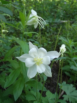
The trail ascends the valley along a moderate grade, while paralleling Coal Creek for much of the route. During the early segments it passes in and out of wooded areas and meadows that offer good views of the surrounding mountains. During our late-June hike we saw a wide assortment of wildflowers along the way, including Colorado columbines, Indian paintbrush, arrow-leaf balsamroot and lupine, among several other varieties. Peak wildflower season in the Teton Pass area usually occurs between mid-July and early-August. During this time period hikers may also find mountain bog gentian, larkspur, harebell, ballhead sandwort, mountain bluebell and Whipple's penstemon.
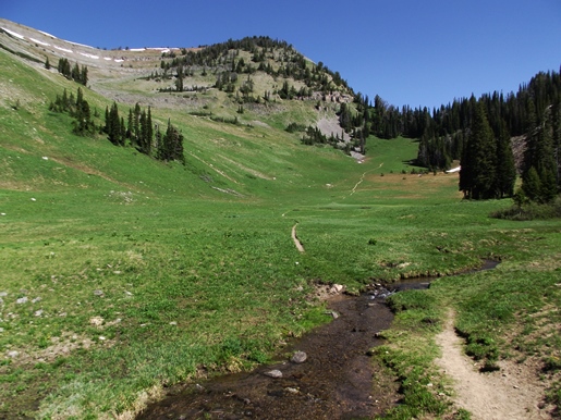
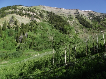 At just over a mile from the trailhead hikers will cross over Coal Creek without the benefit of a footbridge. We didn't have any problems with this crossing; however, it's possible that early spring season hikers could get their feet wet here. Shortly after crossing the stream the trail reaches the lower portions of Coal Creek Meadows. Here you'll enjoy your first good views of 10,352-foot Taylor Mountain towards the northwest. After a brief walk up the valley floor the trail swings right, and begins passing through the woods along the hillside. There are many aspens throughout this stretch, making this a good choice for a fall hike.
As you proceed up the valley between Taylor Mountain and Mount Glory you'll enjoy commanding views of the lower basin area, as well as the Snake River Range rising above the opposite side of the highway. At roughly 1.9 miles the trail ascends to the middle portions of Coal Creek Meadows, which is even more scenic.
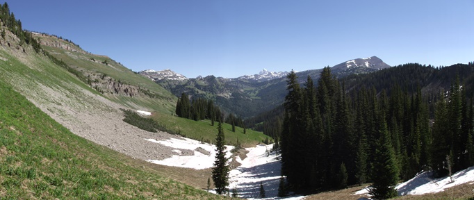
At roughly 2.25 miles the trail reaches the upper level of Coal Creek Meadows. If you continue for another 0.15 miles you'll reach an area that undoubtedly offers the best scenery up to this point. Standing on a slight rise you'll enjoy a commanding view of Coal Creek cutting through the grassy meadow, with Taylor Mountain standing directly across the valley. Many people might choose to end their hike at this spot, which is a very worthy destination; however, if you still have the energy I would highly recommend continuing for less than a half-mile to reach the Coal-Mesquite Divide. You can see the Divide in the photo below. If you look closely you'll notice the trail heading towards the upper right corner of the image. The low point through those trees on the right is Coal-Mesquite Divide.
After hopping across the creek we continued towards our ultimate destination. At roughly 2.7 miles you'll reach the Taylor Mountain Trail (#037) junction. Hikers should continue straight ahead here. From the junction the trail climbs fairly steeply towards the copse of trees. As you near the top of the divide, and emerge from the canopy, it's very likely you'll experience an "oh wow" moment. The expansive views from the divide are quite dramatic. From the summit of the 9185-foot pass you'll be able to see Housetop Mountain (near Marion Lake), Grand Teton and Rendezvous Mountain, the three most prominent mountains looking from left to right.
From the Divide the trail continues with a sharp descent down to Mesquite Creek, and eventually to Moose Meadows. Before reaching Moose Meadows the iconic Teton Crest Trail branches off to the right, and begins its trek towards Marion Lake, Alaska Basin, and eventually Cascade Canyon.