Garnet Canyon
| Trail Features: | Panoramic Views | 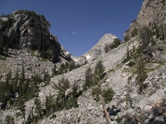 |
|||
| Trail Location: | Lupine Meadows Trailhead | ||||
| Roundtrip Length: | 8.4 Miles | ||||
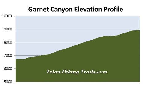
| Trailhead Elevation: | 6732 Feet | ||||
| Total Elevation Gain: | 2240 Feet | ||||
| Avg. Elev Gain / Mile: | 533 Feet | ||||
| Highest Elevation: | 8930 Feet | ||||
| Trail Difficulty Rating: | 12.88 (strenuous) | ||||
| Parking Lot Latitude | 43.73458 | ||||
| Parking Lot Longitude | -110.74158 | ||||
Trail Description:
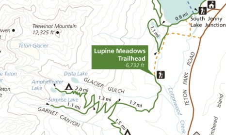
The hike to Garnet Canyon in Grand Teton National Park begins from the Lupine Meadows Trailhead, located just south of Jenny Lake. To reach the trailhead turn west off Teton Park Road at Lupine Meadows junction, located 7 miles north of Moose Junction. The trailhead is located at the end of the gravel road, roughly 1.6 miles from the junction.
From the parking area the trail leads southward while following along the forested periphery of Lupine Meadows. This initial stretch of trail is mostly flat, but soon begins ascending after only a third-of-a-mile. During this stretch the route passes through a mixed conifer forest of lodgepole pine, Engelmann Spruce, subalpine and Douglas fir.
At roughly two-thirds of a mile you'll enjoy a view of 13,770-foot Grand Teton and 12,928-foot Mt. Owen through the trees. Soon afterwards there will be another break in the canopy that offers the first good views of Jackson Hole.
At roughly 1.3 miles the trail begins ascending along a narrow ridgeline, with Burned Wagon Gulch on the left, and Glacier Gulch on the right. This section of trail also offers sporadic views of the Grand Tetons on either side of the ridge.
At just over 1.7 miles hikers will arrive at the Valley Trail junction. A turn to the left would lead hikers down to Bradley Lake and Taggart Lake. To continue on towards Garnet Canyon hikers should proceed straight ahead at this junction.
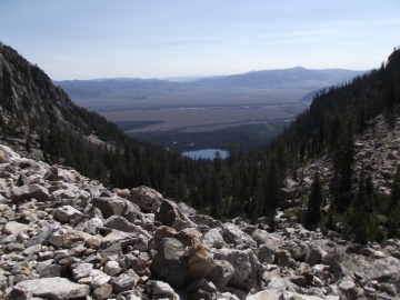 Beyond the junction the trail makes a steep ascent over a couple of long switchbacks. As you climb higher views of Jackson Hole will become even more prominent. Both Bradley Lake and Taggart Lake will eventually come into view as well. I highly recommend starting your hike as early in the morning as possible in order to avoid climbing the steep mountain slopes when the sun is blazing high in the sky.
At roughly 3.1 miles hikers will reach the Garnet Canyon Trail / Amphitheater Lake Trail split. The trail to the right travels another 2 miles to reach Amphitheater Lake. To continue towards Garnet Canyon, hikers should turn left here. Both the Garnet Canyon Trail and the Amphitheater Lake Trail (which was once known as the Glacier Trail), were among the first hiking trails to be constructed in Grand Teton National Park.
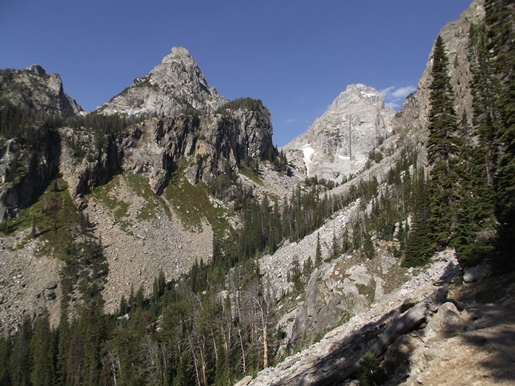
From the junction the trail moderates considerably, running flat for a while before dipping slightly. Soon hikers will enter the mouth of Garnet Canyon where you'll have some absolutely spectacular views of 11,901-foot Nez Perce and 12,804-foot Middle Teton.
Richard "Beaver Dick" Leigh, an itinerant trapper and early tour guide, may have explored this canyon as early as 1858. As a result of his assistance in helping to guide the 1872 Hayden Expedition through the area, Leigh Lake was named after him. Nearby Jenny Lake was named for his wife, a Shoshone Indian who assisted with camp logistics.
At roughly 3.5 miles the trail begins climbing again on a relatively mild to moderate grade. As you proceed upward the route becomes quite rocky as it passes along the talus slopes of Disappointment Peak.
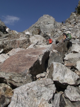
At 4.2 miles hikers will reach the junction for the Platforms Campsites. The main trail officially ends here but you'll have the option of continuing through the boulder field to reach the lower saddle area. Beyond this point the "trail" becomes a difficult and strenuous scramble through a maze of huge boulders. Hikers should expect to be on all fours in order to gain passage through this area, which is roughly one hundred yards in length. You should also note that navigating through this section is fairly difficult, and will likely result in much trial and error as you attempt to pick your way through the maze.
To me the effort really wasn't worth all the trouble. The views are only marginally better on the other side - unless of course you plan to go much deeper into the canyon. I thought the views were quite stunning from the maintained trail side of the boulder field. If you do decide to proceed to the other side you'll have the option of continuing for almost another mile to reach "The Meadows", an area known for its spectacular wildflower displays after the snow melts.
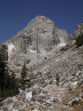
The focal point of the scene near the boulder field is Middle Teton, the third highest peak in Grand Teton National Park. Here you'll have an upfront view of the dike running down the middle of the peak. This 20-to-40 foot thick dike is composed of diabase, a nearly black igneous rock that was formed when molten rock welled up into nearly vertical fissures in the older gneiss rocks.
Hikers should note that snow can linger in the upper portions of the canyon into July. Early season hikers should check with a ranger on conditions before deciding to hike this trail.
You should also note that black bears are frequently seen along the trail. It's best to travel in groups of three or more, make a lot of noise, and carry bear spray while hiking in the Tetons.