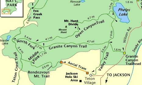
Granite Canyon Loop
| Trail Features: | Panoramic Views, Wildflowers | 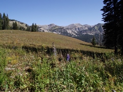 |
|||
| Trail Location: | Aerial Tram - Teton Village | ||||
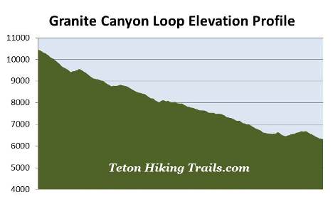
| Roundtrip Length: | 12.9 Miles | ||||
| Trailhead Elevation: | 10,450 Feet | ||||
| Total Elevation Gain: | 640 Feet | ||||
| Avg. Elev Gain / Mile: | 99 Feet | ||||
| Highest Elevation: | 10,450 Feet | ||||
| Trail Difficulty Rating: | 14.18 (strenuous) | ||||
| Parking Lot Latitude | 43.58768 | ||||
| Parking Lot Longitude | -110.82764 | ||||
Trail Description:
The Granite Canyon Loop in Grand Teton National Park begins from the Jackson Hole Aerial Tram in Teton Village. Hikers will have to ride the aerial tram up to the summit of Rendezvous Mountain where the actual hiking begins, thus avoiding the 4139 feet of vertical climbing. A fee is charged for the 12-minute tram ride.
This loop hike begins from the top of Rendezvous Mountain and traverses back down the valley via the Rendezvous Mountain Trail and the Granite Canyon Trail. Hikers will then return back to Teton Village via the Valley Trail.
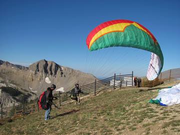 As you might expect, the views from the summit area are quite spectacular. You'll be able to see much of Jackson Hole, Jackson Lake, the Gros Ventre Mountains, as well as Grand Teton towards the north. 10,927-foot Rendezvous Peak will be the prominent mountain towards the southeast. You may even see a few paragliders taking off from the summit area.
After disembarking from the tram and soaking-in the stunning views, walk to the end of the platform and turn left to begin your hike. Hikers will then proceed down a steep gravel service road for just over four-tenths of a mile. The main service road takes a turn towards the left here, while another rough gravel road splits-off and continues straight ahead. Follow this side road as it traverses atop a ridgeline for roughly 0.15 miles, until reaching a sign that indicates the official start of the Rendezvous Mountain Trail. This will be the first trail sign since departing the tram that will indicate you're on the correct route.
Soon after turning onto the Rendezvous Mountain Trail you'll pass a sign marking the Grand Teton National Park boundary. From here the trail descends rapidly through an evergreen forest, dropping almost a thousand feet in roughly eight-tenths of a mile.
At the bottom of the descent the trail immediately begins a moderate climb through fairly open terrain. After a short distance it levels out a bit where you'll likely notice a series of mountains off towards the north. The most prominent peak in this group is 10,783-foot Mt. Hunt.
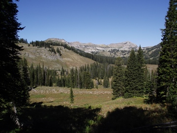 The trail continues through mostly open terrain that offers sweeping views of the surrounding mountains. At roughly 3.7 miles hikers will reach the Middle Fork Cutoff Trail junction. The trail branching off towards the left eventually leads hikers to Marion Lake. To proceed towards Granite Canyon hikers should continue on the Rendezvous Mountain Trail, which branches off to the right.
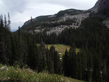
From the junction the Rendezvous Mountain Trail descends along a ridgeline between the Middle and South Forks of Granite Creek. Much of the upper portions of this segment also travels through large open meadows, but eventually enters a dense conifer forest just before crossing the Middle Fork and the North Fork of Granite Creek.
At 5.4 miles hikers will arrive at the Granite Canyon Trail junction. To continue on towards Teton Village hikers should turn right here. However, you may want to take the short side trip to visit the Upper Granite Canyon Patrol Cabin first. This is located only a short distance to the west of the junction, and can be reached by turning left here. Built by the Civilian Conservation Corps in 1935, the cabin was rehabilitated in 2013 after decades of slow deterioration. Today the site is listed on the National Register of Historic Places.
From the junction the trail traverses down to the lower portions of Granite Canyon. As you proceed down the canyon 8426-foot Apres Vous Peak will be the prominent mountain on your right. This peak also stands at the mouth of Granite Canyon.
 The trail continues to meander in and out of open terrain and wooded areas as you proceed towards the lower canyon. Throughout this stretch you'll have several opportunities for spotting moose in the willow-choked creek below.
At just over 10.1 miles hikers will reach the Valley Trail. To continue on towards Teton Village you should turn right here. Shortly thereafter the trail crosses over Granite Canyon Creek, and at 10.3 miles hikers will arrive at the Granite Canyon Trail split. To continue on towards Teton Village you should veer to the right at this junction as well.
The Valley Trail is a pleasant hike through a mixed forest. For the most part it travels over relatively flat terrain, however, there are a couple of short climbs just to make things a little more interesting before returning back to the trailhead.
At roughly 11.9 miles the trail reaches the Grand Teton National Park boundary and begins passing through private property. A short distance later the Valley Trail reaches a gravel road. Hikers should turn left onto this road to continue towards Teton Village. From this point forward trail signage becomes a little confusing, and references to the Valley Trail end. You will now be following two mountain biking trails, the Saratoga Loop and the Summit Trail, to return back to Teton Village. The Summit Trail continues down a ski lift service road where you'll travel between the Apres Vous Ski Lift on one side, and a couple of private homes on the other. Soon the road reaches the outskirts of Teton Village. Simply look for the aerial tram to return back to the parking area.