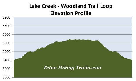
Lake Creek-Woodland Trail Loop
| Trail Features: | Scenic Lake Views | 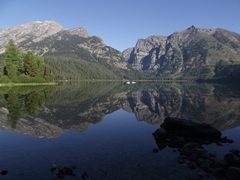 |
|||
| Trail Location: | Laurance S. Rockefeller Preserve | ||||
| Roundtrip Length: | 3.4 Miles | ||||
| Trailhead Elevation: | 6405 Feet | ||||
| Total Elevation Gain: | 260 Feet | ||||
| Avg. Elev Gain / Mile: | 153 Feet | ||||
| Highest Elevation: | 6646 Feet | ||||
| Trail Difficulty Rating: | 3.92 (easy) | ||||
| Parking Lot Latitude | 43.62662 | ||||
| Parking Lot Longitude | -110.77362 | ||||
Trail Description:
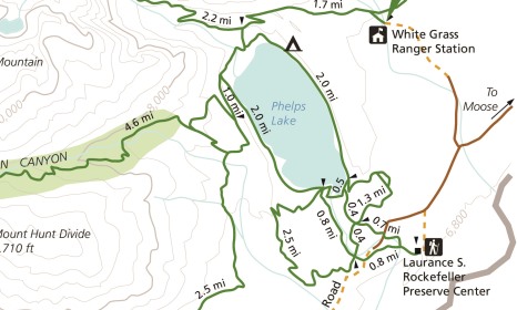
The trailhead for the Lake Creek-Woodland Trail Loop hike is located in the Laurance S. Rockefeller Preserve off Moose-Wilson Road. To reach the trailhead from Moose Junction, turn left onto Moose-Wilson Road and drive roughly 3.6 miles south to the turn-off for the Preserve on the left.
Located near the south end of Phelps Lake, the Laurance S. Rockefeller Preserve is an 1106-acre refuge within Grand Teton National Park. It was originally part of a dude ranch known as the JY Ranch. In 1932, John D. Rockefeller, Jr. purchased the 3100-acre ranch and turned it into a family retreat. Over the years his son, Laurance, transferred much of the ranch to the national park. He donated the remaining 1106-acre parcel in 2001, which would become the Preserve six years later.
 The hike begins with a short walk across a sagebrush flat to reach the LSR Visitor Center. Beyond the visitor center the trail enters a mixed forest dominated by spruce, fir and lodgepole pine.
At just over two-tenths of a mile from the trailhead you'll reach what appears to be an unmarked split in the trail. Actually, the side trail leading towards the left visits a small viewing area just off the main trail. To continue on towards Phelps Lake hikers should stay towards the right.
A short distance later you'll arrive at the Woodland Trail / Lake Creek Trail junction. Although you can take either path, this hike description follows the loop in a clockwise direction. We chose this direction because the views along the Lake Creek Trail are better as you ascend towards Phelps Lake.
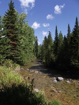
From the junction the Lake Creek Trail immediately crosses a footbridge over Lake Creek. From this point forward the trail more or less follows the creek all the way to Phelps Lake.
At roughly eight-tenths of a mile the trail crosses over Moose-Wilson Road. A short distance beyond the road is the Boulder Ridge Trail / Aspen Ridge Trail junction. This side trails offer hikers the opportunity to explore a larger portion of the Laurance S. Rockefeller Preserve. To continue directly towards Phelps Lake hikers should proceed straight ahead at this junction.
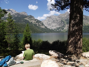 At roughly 1.7 miles hikers will reach the Phelps Lake Trail
junction. Just beyond the junction is a small viewing area along the southern shore of Phelps Lake that offers great views of the
glacially-carved lake and surrounding mountains. Sitting directly across the lake from this vantage point is Death Canyon and 10,552-foot Albright Peak. To the left of the canyon is 11,241-foot Prospectors Mountain. With a surface area of 750 acres, Phelps Lake is the sixth largest lake in Grand Teton National Park.
At roughly 1.7 miles hikers will reach the Phelps Lake Trail
junction. Just beyond the junction is a small viewing area along the southern shore of Phelps Lake that offers great views of the
glacially-carved lake and surrounding mountains. Sitting directly across the lake from this vantage point is Death Canyon and 10,552-foot Albright Peak. To the left of the canyon is 11,241-foot Prospectors Mountain. With a surface area of 750 acres, Phelps Lake is the sixth largest lake in Grand Teton National Park.
After returning to the main trail you should turn and begin heading eastbound (counter-clockwise around the lake) to continue on the loop.
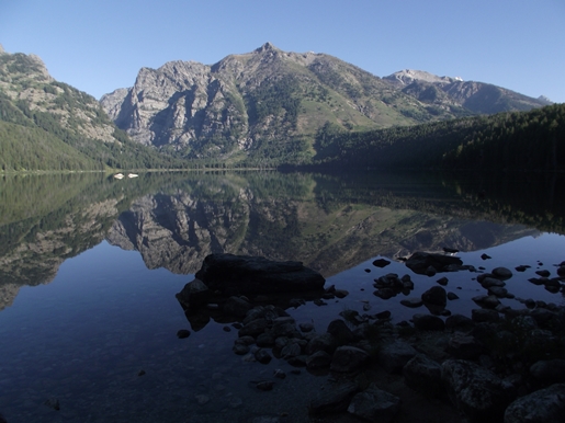
From the junction the trail circles around the southern end of Phelps Lake. At roughly 1.9 miles it crosses over the Lake Creek Bridge, and at roughly 2.1 miles will reach the Woodland Trail junction. Just beyond this junction is another lakeshore access point that offers even better views of the lake and surrounding mountains. This small beach area offers plenty of large rocks and a couple of wooden benches to relax and soak in the magnificent views of Phelps Lake one last time. From this vantage point we watched an osprey soar above the lake while looking for an early morning meal.
From the junction the Phelps Lake Trail circles around Phelps Lake. To continue on the loop hikers should proceed south along the Woodland Trail to return back to the trailhead.
At just over 2.5 miles the trail reaches the Boulder Ridge Trail junction. Hikers should proceed straight ahead here.
At roughly 2.8 miles the trail crosses over Moose-Wilson Road once again, and at roughly 3.1 miles hikers will reach the Woodland Trail / Lake Creek Trail junction. From this point simply retrace your steps back to the trailhead.