Lakeshore Trail
| Trail Features: | Panoramic Views, Lake Views, Wildlife | 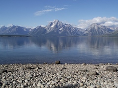 |
|||
| Trail Location: | Colter Bay Visitor Center | ||||
| Roundtrip Length: | 2.1 Miles | ||||
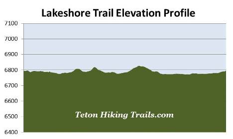
| Trailhead Elevation: | 6796 Feet | ||||
| Total Elevation Gain: | 150 Feet | ||||
| Avg. Elev Gain / Mile: | 143 Feet | ||||
| Highest Elevation: | 6827 Feet | ||||
| Trail Difficulty Rating: | 2.40 (easy) | ||||
| Parking Lot Latitude | 43.90305 | ||||
| Parking Lot Longitude | -110.6443 | ||||
Trail Description:
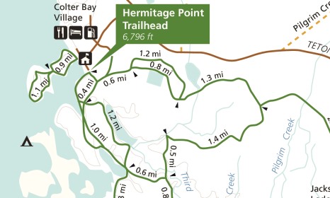
The Lakeshore Trail loop hike begins from the backside of the Colter Bay Visitor Center in Grand Teton National Park. To reach the trailhead, drive 5.4 miles north from Jackson Lake Junction and turn left. From the main highway you'll drive another 0.9 miles, passing though Colter Bay Village to reach the visitor center.
Once behind the visitor center hikers should turn right and begin walking north along the old paved road that circles around the north side of the Colter Bay Marina. The Lakeshore Trail consists of two connecting loops that circle around the inner and outer portions of the wooded peninsula that forms Colter Bay.
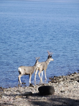
The Colter Bay area provides habitat for a wide variety of wildlife, including bear, moose, elk, mule deer, beaver, muskrat, river otters, sandhill cranes, trumpeter swans, ospreys, great blue herons, as well as snowshoe hares and martens.
 The bay is named for John Colter, a key member of the Lewis and Clark expedition. Although evidence is inconclusive, Colter may have been the first Euro-American to visit the Grand Tetons. During the winter of 1807-08 Colter explored the greater Yellowstone area. His route, however, is uncertain. One theory holds that he traveled via Togwotee Pass. The other commonly held view traces Colter's route through Jackson Hole, over Teton Pass, and north along the west side of the Teton Range. No clear evidence exists to substantiate either route, only vague accounts and maps derived from interviews with Colter after his return. However, in 1933, an interesting stone was discovered near Tetonia, Idaho that may offer proof of the second theory. The stone has the name "John Colter" carved into it, and if authentic, would prove that Colter did travel the Teton Pass route. Unfortunately the Colter Stone has never been fully authenticated.
At roughly a quarter-of-a-mile from the visitor center hikers will reach a trail junction with a sign that reads "Motorized Vehicles and Bicycles Not Permitted on Foot Path." The Lakeshore Trail officially begins by turning right at this junction. From this point the paved portion of the inner loop ends and a normal dirt footpath begins.
At four-tenths of a mile hikers will reach another junction. The inner loop portion of the hike continues towards the right. To continue on towards the outer loop, which ventures out to the end of the peninsula, hikers should veer to the left at this junction.
From the junction hikers will travel across a natural causeway between the two "islands." Once on the other side you'll arrive at the outer loop trail junction. Although you can continue in either direction, we turned left and proceeded in a clockwise direction.
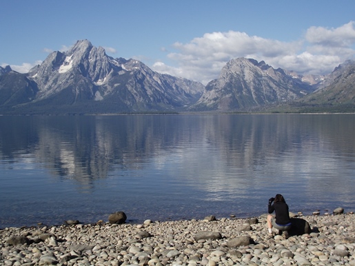
At just over nine-tenths of a mile hikers will reach a rocky beach area that offers some absolutely outstanding views. Looking from left to right you'll be able to see Teewinot Mountain, Grand Teton, Mt. Moran, Bivouac Peak, Eagles Rest Peak and Ranger Peak rising above Jackson Lake's western shore.
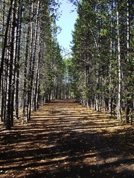
For the most part the outer loop travels through a conifer forest on relatively flat terrain. However, there are a couple of short easy climbs hikers will have to tackle along the way.
At just over 1.5 miles hikers will reach the end of the outer loop. From the junction you'll turn left and proceed across the causeway to reach the inner loop trail junction once again. To complete the loop hike you should turn left once again.
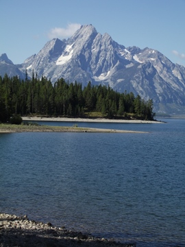
From the causeway the trail hugs the shoreline, while offering some outstanding views of the northern Tetons. This final leg of the hike is almost completely flat.
At just over 2 miles you'll reach another fork in the trail. The left fork heads towards the picnic area. To continue back towards the visitor center you should veer to the right here. As you approach the end of the hike you'll want to circle around the top side of the amphitheater to return back to the visitor center.