
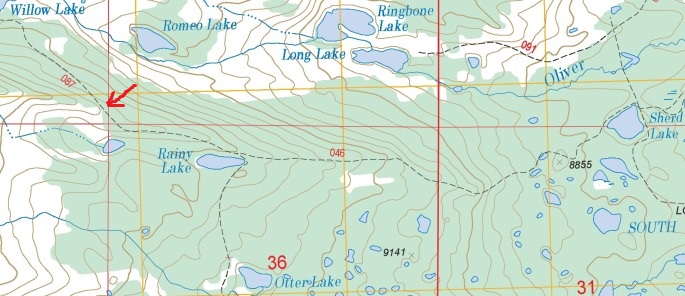
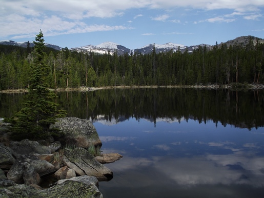
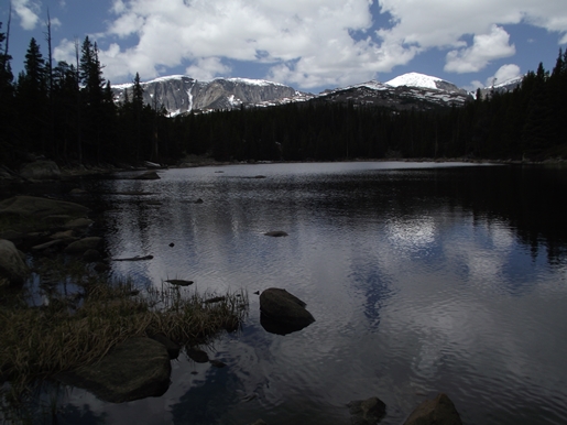
Rainy Lake
| Trail Features: | Scenic Lake Views | 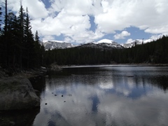 |
|||
| Trail Location: | Circle Park Trailhead | ||||
| Roundtrip Length: | 6.8 Miles | ||||
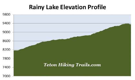
| Trailhead Elevation: | 8170 Feet | ||||
| Total Elevation Gain: | 1265 Feet | ||||
| Avg. Elev Gain / Mile: | 372 Feet | ||||
| Highest Elevation: | 9392 Feet | ||||
| Trail Difficulty Rating: | 9.33 (moderate) | ||||
| Parking Lot Latitude | 44.27659 | ||||
| Parking Lot Longitude | -106.98502 | ||||
Trail Description:
The hike to Rainy Lake begins from the Circle Park Trailhead in the Bighorn National Forest near Buffalo, Wyoming. To reach the trailhead from I-25 in Buffalo, drive 15.7 miles west on US Highway 16, also known as the Cloud Peak Skyway, to Circle Park Road, also known as Forest Service Road 20. Look for Circle Park Road on the right side of the highway, roughly 1.2 miles past the YMCA of the Bighorns. Circle Park Road is an unpaved gravel road with your typical potholes and washboard, but is appropriate for passenger vehicles as long as you take your time. After driving 2 miles you'll reach a fork in the road. Turn left onto Forest Service Road 384, and drive another half-mile to reach the trailhead.
From the parking lot the hike begins in a fairly thick coniferous forest. Hikers will travel along the Sherd Lake Loop Trail (#046), sometimes referred to as the Circle Park Loop, which is a fairly popular route in the Bighorn National Forest. Originally established as a U.S. Forest Reserve in 1897, the Bighorn National Forest is one of the oldest federally-protected forest lands in the United States. It provides habitat for elk, moose, mule deer, pronghorn, black bear and mountain lion, has over 1500 miles of trails, and protects more than 1.1 million acres.
At roughly eight-tenths of a mile from the trailhead hikers will reach the Cloud Peak Wilderness boundary, and shortly thereafter, will pass through a rickety metal gate. Designated by Congress in 1984, the Cloud Peak Wilderness protects more than 189,000 acres, including Cloud Peak Glacier, the only active glacier remaining in the Bighorn Mountains. The Wilderness also protects the highest peaks in the Bighorn National Forest, including 13,167-foot Cloud Peak and 13,005-foot Black Tooth Mountain.
For the most part the trail ascends along a moderate grade, while at times traveling over some fairly rugged terrain, including many small and large rocks strewn across the path.
At just under 1.5 miles you'll reach an unnamed lake. It's a nice little pond, but nothing extraordinarily special. During our visit we saw quite a bit of recent beaver activity, including a fairly large lodge in the middle of the lake. We also noticed the stumps of the trees that the beavers used to make their home.
At 1.8 miles hikers will arrive at the Trail #095 junction, located near the northeastern shore of Sherd Lake. This lake is a great destination and a great place to take an extended break. Upon arrival I highly recommend walking about 100 yards towards the south, along Trail #095, where the views of the surrounding mountains are far more scenic. From its eastern shore you'll enjoy good views of 12,324-foot Bighorn Peak and 12,275-foot Darton Peak rising above the trees on the opposite side.
To continue on towards Rainy Lake, the trail proceeds towards the north - away from the lake. After walking about 100 yards you'll reach another junction where Trail #047 splits off towards Long Lake and Ringbone Lake. To proceed towards your ultimate destination you should veer left and continue along Trail #046.
At roughly 2.9 miles the trail begins to ascend a narrowing ridge where the trees on your right have thinned-out a bit. During this stretch you'll have intermittent views of Long Lake and Ringbone Lake in the valley below.
At 3.3 miles hikers will reach the Trail #087 junction, which leads to the Cloud Peak Wilderness Overlook and Willow Lake. To continue towards Rainy Lake hikers should turn left to remain on the Sherd Lake Loop Trail (#046). After traveling no more than a hundred yards or so you'll notice Rainy Lake lying just down the hill on your right. Unfortunately a side trail to the lake doesn't exist, so you'll simply have to find the easiest route down to its eastern shore. This short and easy "bushwhack" drops down about 40 feet or so from the main trail to reach the shoreline. From Rainy Lake you'll enjoy even better views of Bighorn Peak and Darton Peak towards the west.
After soaking in the views at Rainy Lake hikers will have the option of continuing on for another half-mile to visit Otter Lake.