South Rim - Clear Lake Loop
| Trail Features: | Oustanding Views, Waterfalls | 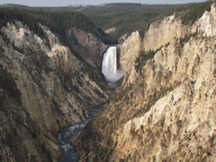 |
|||
| Trail Location: | Canyon Village | ||||
| Roundtrip Length: | 5.1 Miles | ||||
| Trailhead Elevation: | 7740 Feet | ||||
| Total Elevation Gain: | 1116 Feet | ||||
| Avg. Elev Gain / Mile: | 438 Feet | ||||
| Highest Elevation: | 7921 Feet | ||||
| Trail Difficulty Rating: | 7.33 (moderate) | ||||
| Parking Lot Latitude | 44.70804 | ||||
| Parking Lot Longitude | -110.50118 | ||||
Trail Description:
The South Rim - Clear Lake Loop hike in Yellowstone National Park begins from the Wapiti Lake Trailhead, located on South Rim Drive just past the Chittenden Bridge spanning across the Yellowstone River. Look for a paved path on the west side of the parking lot that leads down to the road. Just before reaching the bridge look for a wood sign indicating the start of the South Rim Trail.
Although this page describes a 5.1-mile loop hike, you’ll have the option of ending your hike at Artist Point if you have two vehicles in your party, and wish to only see the Grand Canyon of the Yellowstone. This one-way option would be only 2.2 miles in length.
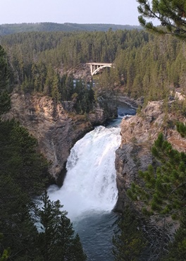 After walking roughly six-tenths of a mile from the parking lot, hikers will reach the short side path that leads to Sunset Point, and at nine-tenths of a mile will reach Upper Falls Viewpoint. Both perches offer hikers the chance to see, hear and feel the Upper Falls of the Yellowstone River as it plunges 109 feet over the edge of a cliff.
Near the Upper Falls View overlook is the parking lot for Uncle Tom’s Trail. To continue along the South Rim Trail you should stay to the left at the junction to proceed towards Uncle Tom’s Trail. At roughly 1.1 miles hikers will arrive at Uncle Tom’s Trail, a side path that drops precipitately into the canyon for an up-close view of the Lower Falls. Unfortunately this historic route was closed during our visit due to a multi-year restoration project. If you were to take this steep trail down to the viewing platform it would add roughly a half mile to your overall mileage, and another 500 feet of elevation gain.
The original “trail” into the canyon was constructed in 1898 by “Uncle Tom” Richardson after receiving a permit from the park to ferry tourists across the Yellowstone River near the site of today's Chittenden Bridge, and then guide them down into the canyon using his route. The original “trail” included 528 steps and rope ladders that allowed intrepid tourists to reach the floor of the canyon. Richardson operated the toll trail and ferry service until 1905, but his business waned after construction of the Chittenden Bridge in 1903. Over the years the park shortened the number of stairs into the canyon, and eventually installed grated metal stairs to help withstand damage from heavy snowfall each winter. Today the trail descends along 328 steps, which take visitors roughly three-quarters of the way down into the canyon.
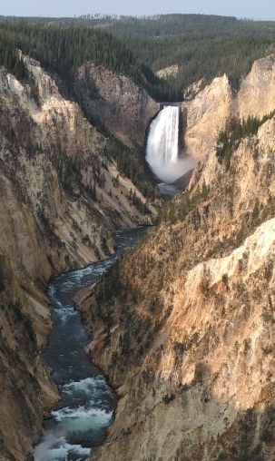 From the Uncle Tom’s Trail junction the South Rim Trail continues towards the next destination at Artist Point. At just under 2 miles hikers will reach the Artist Point parking lot. You should continue walking through the large lot to reach the short trail to Artist Point, one of the most photographed spots in the entire park. The overlook provides an unobstructed view of the Lower Falls, which is perfectly framed by both canyon walls. In all, the Grand Canyon of the Yellowstone stretches for roughly 24 miles, is nearly 1200 feet deep in some areas, and has a width of 1500 to 4000 feet. The colorful canyon walls are mostly made of rhyolite, altered rhyolite and tuff.
From Artist Point the Yellowstone River continues to run freely on a northeasterly course. Overall, it flows 671 miles before emptying into the Missouri River in North Dakota, making it the longest free-flowing river in the lower 48.
Many people think that Artist Point is the location where Thomas Moran painted “The Grand Canyon of the Yellowstone”, which helped to inspire Congress to designate Yellowstone as the first national park in 1872. The historic spot, however, is actually located at Moran Point on the North Rim. The confusion over the location first arose when Yellowstone photographer F. Jay Haynes mistakenly named the overlook for Moran in his 1890 guidebook.
After soaking-in the majestic views at Artist Point hikers should proceed to the far end of the viewing area to reach the Artist Point Trailhead. The loop hike continues by following the trail towards Ribbon Lake. This segment of the loop continues to travel along the South Rim for roughly two-thirds of a mile. At roughly 2.9 miles hikers will arrive at the turnoff for Lily Pad Lake, the next destination on this hike. Continuing on the main trail here will lead you to Sublime Point, located roughly one mile away. You should turn right at this junction to stay on the loop.
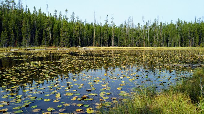
At 3.1 miles the trail reaches Lily Pad Lake, an unassuming pond lined with lily pads, as you might expect. From the lake you should continue on the main trail to reach the Clear Lake-Ribbon Lake Trail junction, located only a couple hundred yards past the lake. At the junction hikers should turn right to head towards Clear Lake, the final destination on this hike.
Just beyond the junction the trail begins to pass through a long stretch of thermal activity that will almost give you the impression that you’re walking across a moonscape. In this area hikers will also pass a couple of gurgling mud pots and steam vents.
At 3.8 miles hikers will reach Clear Lake, which is fed by hot springs. If you look closely at the emerald green water you'll likely notice small bubbles rising to the surface.
Just beyond the lake, at 4.1 miles, hikers will reach the Clear Lake Trail junction. The Clear Lake Trail leads back to the Uncle Tom’s Trail parking lot. To continue towards the Wapiti Lake Trailhead you should veer left to remain on the Clear Lake-Ribbon Lake Trail.
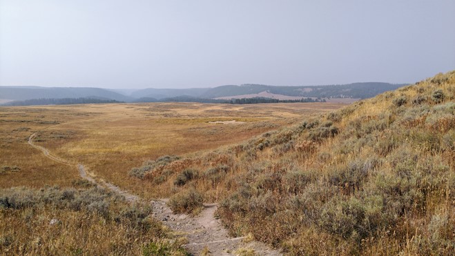
From the junction the trail ascends a low grassy hill that offers spectacular views towards the south and west. For much of the remainder of the hike it will travel through grassland meadows, which provide great opportunities for spotting bison. At roughly 4.7 miles you'll reach the Wapiti Lake Trail junction. You should continue straight ahead along the main trail to return back to the trailhead, located roughly four-tenths of a mile away.
Additional Resources:
* Yellowstone National Park website
* Trail Map (trails are not included on the official park map)
* Lonely Planet Yellowstone & Grand Teton National Parks