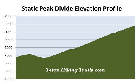
Static Peak Divide
| Trail Features: | Outstanding Panoramic Views, Wildflowers | 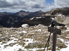 |
|||
| Trail Location: | Death Canyon Trailhead | ||||
| Roundtrip Length: | 16.3 Miles | ||||
| Trailhead Elevation: | 6807 Feet | ||||
| Total Elevation Gain: | 5000 Feet | ||||
| Avg. Elev Gain / Mile: | 613 Feet | ||||
| Highest Elevation: | 10,790 Feet | ||||
| Trail Difficulty Rating: | 26.30 (strenuous) | ||||
| Parking Lot Latitude | 43.65597 | ||||
| Parking Lot Longitude | -110.78128 | ||||
Trail Description:
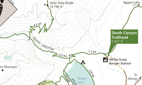
The hike to Static Peak Divide in Grand Teton National Park begins from the Death Canyon Trailhead. To reach the trailhead from Moose Junction, turn left onto Moose-Wilson Road and drive roughly 3 miles south to reach the turn-off for the Death Canyon Trailhead. Turn right and drive another 2 miles to the end of the road. Although the first mile is paved, the last mile travels over a fairly rugged gravel road. The park highly recommends using a 4-wheel drive vehicle to reach the trailhead. At the point where the paved road ends there's a small parking area that allows people in 2-wheel drive vehicles to park and walk the last mile to the trailhead.
The hike begins with a moderate climb through a lodgepole pine forest. After walking a very short distance you’ll reach the Valley Trail junction. You should turn left here to continue towards Static Peak Divide.
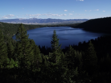
At exactly one mile hikers will arrive at the Phelps Lake Overlook. Resting at an elevation of 7200 feet, this perch stands 567 feet above Phelps Lake, and offers outstanding panoramic views. The glacially-carved lake has a surface area of 750 acres, making it the sixth largest lake in Grand Teton National Park. While at the overlook take note of the old-growth Douglas firs nearby, some of which are estimated to be between 300 and 400 years old.
 From the overlook the trail travels down to the valley floor where you'll have access to the lake. As the trail descends you'll enjoy additional views of the lake, as well as some outstanding views of the mouth of Death Canyon.
At just over 1.7 miles hikers will arrive at the Death Canyon Trail junction. A turn to the left will lead you down to a small sandy beach along the northern shore of the lake. To continue towards Static Peak Divide hikers should proceed straight ahead. From this point forward you'll be traveling along the Death Canyon Trail.
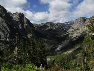
At roughly 2.25 miles the trail more or less enters the mouth of Death Canyon. Soon hikers will begin climbing again, ascending along a moderately strenuous grade while paralleling Death Canyon Creek all the way up to the Death Canyon Patrol Cabin. Views up the canyon, as well as back down the valley towards Phelps Lake and Jackson Hole are quite amazing throughout this stretch.
The dramatic U-shaped valley of Death Canyon, which can also be seen from Highway 89 near the airport, was formed by glaciers roughly 15,000 years ago. The glacial process has exposed the trail to some of the oldest rocks on the surface of the earth, some of which are estimated to be nearly 2.7 billion years old.
At 3.7 miles the trail reaches the upper portions of the canyon. The grade moderates dramatically here, and travel becomes much easier.
As you proceed through the canyon you should keep an eye out for bears. While black bears are frequently seen in Death Canyon, grizzly bears are becoming more common. As a result, hikers are advised to travel in groups of three or more, carry bear spray, and make a lot of noise. You should also be on the lookout for moose feeding on the willows near the creek.
Nearly 4 miles from the trailhead hikers will arrive at the Alaska Basin Trail junction. Located here is the historic Death Canyon Patrol Cabin, which was originally constructed as a barn by the Civilian Conservation Corps in 1935, but became a ranger patrol cabin in 1945. The cabin is now listed on the National Register of Historic Places.
To continue towards Static Peak Divide hikers should turn right onto the Alaska Basin Trail.
 From the junction the trail almost immediately begins climbing again. Much of this stretch travels along a moderately strenuous to fairly strenuous grade. As you climb higher the terrain also becomes quite steep, so you'll want to exercise caution while traversing the switchbacks.
As you ascend along the western slopes of Albright Peak hikers will enjoy spectacular views of Death Canyon, as well as the Death Canyon Shelf, a narrow, four-mile plateau. Rising just above the shelf is 10,916-foot Fossil Mountain and 10,966-foot Mt. Bannon.
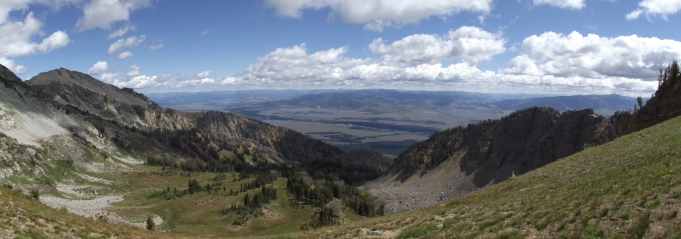
At 6.6 miles you'll reach the top of the canyon wall where you'll enjoy an absolutely spectacular view of Phelps Lake, Jackson Hole and the Gros Ventre Mountains towards the east. This overlook sits atop of a narrow ridge jutting off the southwestern flank of Albright Peak. From the overlook the grade moderates for a very short distance, but soon resumes its relentless ascent towards the divide.
At roughly 7.3 miles hikers will reach the saddle between 10,552-foot Albright Peak and 11,303-foot Static Peak. For the first time you'll be able to see Static Peak and the area surrounding the divide. You'll also have another awesome view of Jackson Hole and the Gros Ventre Mountains.
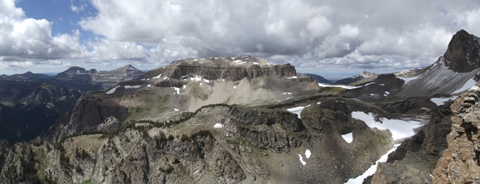
From the saddle hikers will crisscross over a series of short switchbacks, and at just over 8.1 miles, will finally reach Static Peak Divide. The official elevation here is 10,790 feet, making this the highest mountain pass along any maintained trail within the park. Simply put the views from the top are absolutely epic, which easily makes this one of the best hikes in Grand Teton National Park, in my opinion. Towards the east you'll be able to see Jackson Hole, as well as the Wind River Range out in the far off distance. Towards the southwest will be Death Canyon, as well as Rimrock Lake lying just below the summit of 11,241-foot Prospectors Mountain. Further to the west will be the Death Canyon Shelf, Fossil Mountain and Mt. Bannon. Views into the Alaska Basin towards the northwest are outstanding as well. The jagged pinnacles directly to the north is 11,938-foot Buck Mountain, and the large peak looming above you, just towards the northeast, is Static Peak.
If you still have plenty of time and energy, hikers will have the option of continuing to the summit of Static Peak. This will require another 513 feet of climbing over the course of a half-mile trek along an unofficial trail.
As you may have guessed, Static Peak received its name due to the frequency it's struck by lightning. Even if you don't go to the summit, hikers should always be aware of lightning risk while hiking in the Grand Tetons, especially at higher elevations. As a general rule of thumb you should plan to turnaround before noon in order to avoid the notorious afternoon thunderstorms that frequent the mountains during the summer months. Hikers should also be prepared for extreme sun exposure, high winds, cool temperatures, and rapidly changing weather conditions while on the trail. Make sure you have the proper gear with you, and know what safety precautions you need to consider beforehand.
Hikers should also note that snow and ice can linger along the higher elevations of the Alaska Basin Trail through July. Early season hikers should check on conditions with a ranger before deciding to take this hike.