Taggart Lake-Bradley Lake Loop
| Trail Features: | Panoramic Views, Lake Views, Fall Aspens | 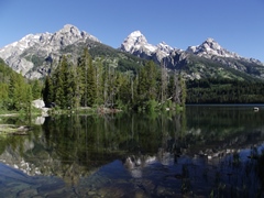 |
|||
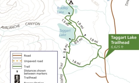
| Trail Location: | Taggart Lake Trailhead | ||||
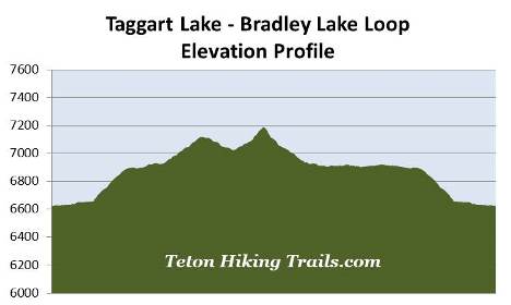
| Roundtrip Length: | 5.5 Miles | ||||
| Trailhead Elevation: | 6625 Feet | ||||
| Total Elevation Gain: | 585 Feet | ||||
| Avg. Elev Gain / Mile: | 213 Feet | ||||
| Highest Elevation: | 7190 Feet | ||||
| Trail Difficulty Rating: | 6.67 (moderate) | ||||
| Parking Lot Latitude | 43.69313 | ||||
| Parking Lot Longitude | -110.73299 | ||||
Trail Description:
The Taggart Lake-Bradley Lake Loop hike begins from the Taggart Lake Trailhead, located roughly 2.3 miles north of the Moose Entrance Station in Grand Teton National Park. This hike visits two of the six glacially-formed lakes that lie at the base of the Teton Range.
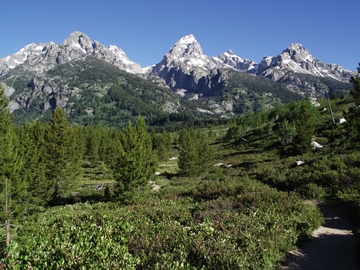
From the trailhead hikers will immediately enjoy stunning views of Grand Teton towering above the sagebrush flat. At 13,770 feet, Grand Teton is the highest mountain in the Teton Range. The peak was renamed as Mt. Hayden by the 1872 Hayden Geological Survey, but most people continued to call it Grand Teton Peak. In 1931 the U.S. Board of Geographic Names recognized its more common name, and then shortened it to Grand Teton in 1970.
 The first documented ascent of the peak occurred on August 11, 1898 by four climbers. Two members of the Hayden Geological Survey claimed to have reached the summit on July 29, 1872. However, that ascent is disputed by climbers and historians who have concluded, after studying the climber's accounts, that the two reached a side peak known as The Enclosure. Moreover, the 1898 climbers found no evidence of a previous ascent, including a cairn which was a common practice for the expedition.
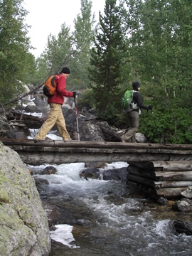
At just over one-tenth of a mile from the trailhead hikers will reach a fork in the trail. The Beaver Creek Trail leads to the left. Hikers should veer to the right to continue along the Taggart Lake Trail. After walking another tenth-of-a-mile you'll arrive at another split where an old gravel road forks off to the left. Hikers should remain on the footpath that leads to the right to continue on towards Bradley Lake and Taggart Lake. A short distance beyond the junction you'll cross a footbridge over Taggart Creek which offers a nice view of a cascading waterfall just upstream from the bridge.
 At just over four-tenths of a mile hikers will pass the NPS horse corrals. Soon afterwards the trail begins climbing a moderate grade towards Taggart Lake. This section of trail more or less follows along Taggart Creek, while traveling through a mixed forest of spruce, fir and lodgepole pine. You'll also pass through some long stretches of aspen groves, making this an excellent choice for a fall hike.
At just over a mile from the trailhead you'll begin passing through an area that was burned during the 1985 Beaver Creek Fire. The lightning-ignited wildfire charred more than a thousand acres, and was reported to be so intense that it "exfoliated 8 to 10 cm of stone from granite boulders". As a result, hikers now have excellent opportunities for spotting a wide variety of wildlife that are now taking advantage of the new growth, as well as the decaying trees. This will include mountain bluebirds, flycatchers, woodpeckers, owls, marmots, elk, mule deer and bears. Throughout this stretch hikers will also enjoy outstanding views of the mountains looming towards the west.
At just over 1.1 miles you'll reach the Bradley Lake Trail junction. The trail leading to the left takes hikers directly up to Taggart Lake. However, to visit both lakes, you should stay to the right to visit Bradley Lake first.
This next segment of the route mostly travels through open terrain, while also passing through a few young aspen groves. At roughly 1.6 miles you'll begin passing a series of overlooks that offer some decent views of Taggart Lake lying some two hundred feet below.
At just over 2.1 miles hikers will arrive at the Valley Trail junction. Although it doesn't mention it on the trail sign, you should turn right here to visit Bradley Lake. In less than a tenth-of-a-mile you'll reach the eastern shore of the lake.
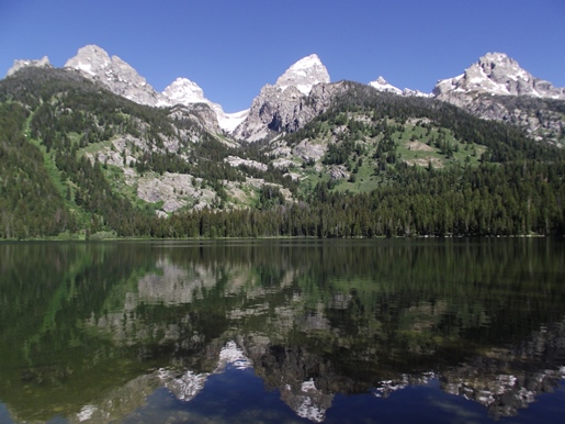
At roughly 225 acres, Bradley Lake is the smallest of the chain lakes that lie at the base of the Teton Range. The glacially-carved lake is fed by Garnet Creek, which flows off Middle Teton Glacier. The lake was named for Frank Bradley, the Chief Geologist for the 1872 Hayden Survey Expedition.
The views from the lake are simply outstanding. From the eastern shore hikers will be able to see 11,901-foot Nez Perce, 12,804-foot Middle Teton, Grand Teton, and 12,235-foot Teewinot Mountain.
To continue on the loop hike, after you're done soaking in the sublime views, you'll have to return back to the Valley Trail / Bradley Lake Trail junction. From the junction you'll veer to the right and begin heading south along the Valley Trail.
From the junction the trail travels through a pristine spruce-fir forest just above the southern shore of Bradley Lake. As the trail climbs the moraine between Taggart Lake and Bradley Lake, hikers will also pass through a fairly long stretch of huckleberries. You'll definitely want to make a lot of noise to warn any bears that might be around that you're passing through their territory.
After ascending to the top of the ridge the trail almost immediately begins descending on the other side. Along this stretch you'll enjoy additional birds-eye views of Taggart Lake lying roughly 300 feet below.
During our most recent hike, along this stretch of trail, we abruptly stopped after hearing a ruffed grouse off to the side of the trail. As we stood there waiting for him to make another “drumming” sound, or possibly appear in the open, we heard a noise behind us, on the other side of the trail. Scanning through the trees and brush we suddenly saw a black bear casually approaching our direction. Given the situation, we simply walked away, while making sure our bear spray was ready if needed.
At almost 3.4 miles hikers will finally reach the northeastern corner of Taggart Lake. The trail continues to follow along its eastern shore for the next four-tenths of a mile, and at 3.8 miles, will reach the Taggart Lake Trail junction. From here you'll have access to a small beach area that offers outstanding views of 12,804-foot Middle Teton, Garnet Canyon, Grand Teton, 12,928-foot Mt. Owen and 12,235-foot Teewinot Mountain.
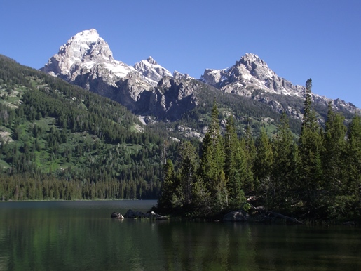
This 305-acre, glacially-carved lake was named for William Rush Taggart, an assistant geologist under Frank Bradley during the Hayden Geological Survey of 1872. Both Taggart and Bradley were among the party that attempted to climb Grand Teton during that expedition.
This popular loop hike returns via the Taggart Lake Trail. However, if you wish to explore more of the terrain in this part of the park, you could return to the trailhead via the Beaver Creek Trail, which would add only another half-mile to your overall hike.