Freds Mountain
| Trail Features: | Outstanding Panoramic Views | 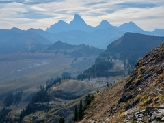 |
|||
| Trail Location: | Bannock Trailhead at Grand Targhee Resort | ||||
| Roundtrip Length: | 6.3 Miles | ||||
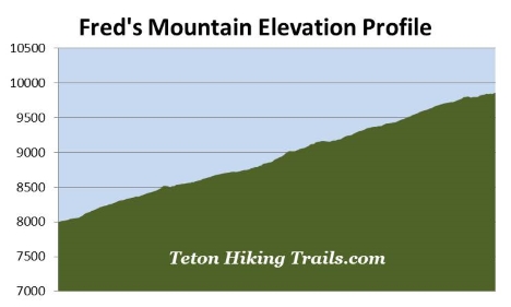
| Trailhead Elevation: | 7975 Feet | ||||
| Total Elevation Gain: | 1910 Feet | ||||
| Avg. Elev Gain / Mile: | 606 Feet | ||||
| Highest Elevation: | 9862 Feet | ||||
| Trail Difficulty Rating: | 10.12 (strenuous) | ||||
| Parking Lot Latitude | 43.78897 | ||||
| Parking Lot Longitude | -110.95709 | ||||
Trail Description:
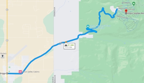
The hike to Freds Mountain begins from the Bannock Trailhead, located near the Dreamcatcher chairlift in Grand Targhee Resort just west of Grand Teton National Park. To reach the Bannock Trailhead, drive 12 miles east on Ski Hill Road from downtown Driggs, Idaho. From the main parking area, head towards the left side of the Dreamcatcher chairlift where you’ll see an unmarked trail zig-zagging up the hill. During our hike, in mid-September, the resort had already removed all of their trail signs in preparation for the upcoming ski season. With trail signs in place, navigating through all of the trail and road junctions should be much easier than my directions seemingly indicate.
Regardless, hikers will follow the Bannock Trail all the way to the summit of Freds Mountain. As mentioned, the trail passes near or crosses over a labyrinth of service roads, footpaths and mountain biking trails. In fact, shortly after departing from the trailhead, the trail crosses a service road. Before I run through the specific route instructions, note the map below. This map is oriented as if you were looking at the mountain from its base. Additionally, the left side of the map points to the north. For a much larger version of this map, please click here.
0.15 miles: turn right at the trail junction and continue up the steep hill towards frisbee golf course hole #2. From here the trail skirts along the edge of an aspen grove. At roughly one-third of a mile you’ll emerge from that grove and begin cutting across the ski slope towards the Dreamcatcher chairlift.
 0.60 miles: the foot trail essentially dead ends at a service road. Hikers should cross over the road and begin ascending the gravel road that leads up the hill on the opposite side.
0.73 miles: turn left onto the foot trail branching off the road (towards the north).
0.80 miles: the Bannock Trail reaches a trail junction that makes a narrow “X”. You should take the trail branching off towards the right here. This trail runs parallel with the trail on the left for a short distance, but traverses at a higher contour. From here the trail continues to cut across the mountain, heading in a northerly direction. As you continue along this long stretch, spectacular views towards the west open up.
0.96 miles: the trail passes beneath the Blackfoot chairlift.
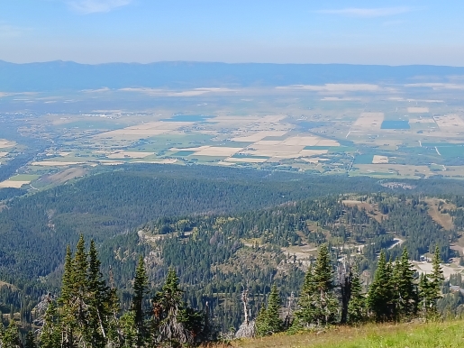
1.43 miles: the trail continues along this stretch until reaching a major switchback. This switchback, at roughly 1.43 miles, marks the most northern part of the route. Here you’ll enjoy your first view of the Grand Tetons. From this point forward you’ll begin ascending the ridge towards the top of Freds Mountain.
1.70 miles: the trail briefly morphs into a service road, but at 1.75 miles the Bannock foot trail branches off to the left, while the service road continues straight ahead. You should turn left here and proceed upward. You might be tempted to take the service road, but there are some extremely steep sections along this route. The foot trail traverses along several switchbacks, thus making the climbing easier.
2.20 miles: at just under 2.2 miles the trail approaches the Blackfoot chairlift, but makes an abrupt switchback before actually reaching it. The trail, however, passes above the lift shortly thereafter.
2.40 miles: hikers will reach another unmarked (at the time of our hike) trail junction. You should stay to the left here.
2.57 miles: the foot trail reaches the service road once again. This time you’ll begin ascending along the steep road.
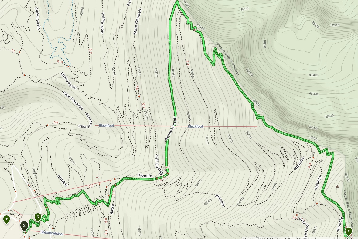
2.90 miles: hikers will reach the area just below the top of the Dreamcatcher chairlift. You should notice a steel grated platform off to the side that offers outstanding views of the Grand Tetons and surrounding area. Though you could finish your hike here, there are slightly better views at the top of the mountain. Simply retrace your steps after visiting the platform, back towards the chairlift, and continue walking past it and the hut. You’ll eventually reach a sign indicating the trail to the summit is towards the left.
3.13 miles: from this junction the summit is a relatively short and easy walk up the hill.
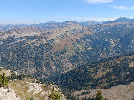
The summit area provides stunning 360-degree views. Visible from the summit are Mt. Moran, Mt. Woodring, Mt. Owen, Grand Teton, Middle Teton and South Teton in the Teton Range. Most people see the Grand Tetons from the east. I would imagine most of them would agree that this view offers one of the most iconic views of any mountain range in the United States. However, Freds Mountain offers a much different perspective, and gives you a chance to see how much taller Grand Teton is from the rest of the range. Unfortunately our photos really don’t do this view justice. There was a little bit of smoke in the air from nearby forest fires. Moreover, since we started the hike first thing in the morning, we were still looking into early morning haze created by the sun. If you don’t mind hiking in the heat, it’s likely you’ll enjoy much better views during the afternoons.
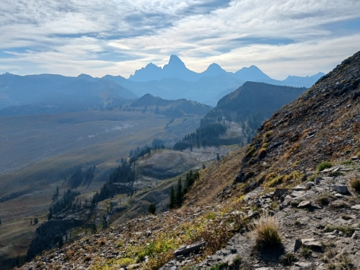
Also visible from the summit is Table Mountain, which was made somewhat famous after Harrison Ford, the actor and longtime resident of Jackson, and a helicopter pilot, rescued a hypothermic hiker from the peak in 2000.
The Bannock Trail is a fairly rocky and rugged trail. Even though it’s located within a major ski resort, it’s still a good idea to carry bear spray. We did see a black bear in the valley as we were hiking along the spine of the ridge. Also, for those who have plenty of time and energy, you can continue along the trail down to Mary’s Saddle, then circle around Mary’s Nipple (yes, that’s its official name), and climb to the top of Peak 9943, which will provide an even more up-close view of the Grand Tetons. This section appears to be very rugged as well, so be sure to take a good topo map.
Freds Mountain is named for Fred Clark, a member of Ferdinand Hayden’s Geological Survey of 1872, which essentially put the Yellowstone and Grand Teton region on the map. Alternatively, Grand Targhee takes its name from a “notorious” Bannock Indian chief who died in a battle with the Crow Indians during the winter of 1871-72.