Lava Lake
| Trail Features: | Scenic Lake Views | 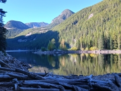 |
|||
| Trail Location: | Lava Lake Trailhead | ||||
| Roundtrip Length: | 5.5 Miles | ||||
| Trailhead Elevation: | 5535 Feet | ||||
| Total Elevation Gain: | 1605 Feet | ||||
| Avg. Elev Gain / Mile: | 584 Feet | ||||
| Highest Elevation: | 7105 Feet | ||||
| Trail Difficulty Rating: | 8.71 (moderate) | ||||
| Parking Lot Latitude | 45.4064 | ||||
| Parking Lot Longitude | -111.22442 | ||||
Trail Description:
The hike to Lava Lake begins from the Lava Lake Trailhead, located roughly 28 miles south of Bozeman, Montana. The turn-off for the trailhead is located off U.S. Highway 191 on the northwest side of the bridge that spans the Gallatin River, between mile markers 61 and 62. The trailhead is signed on both sides of the highway. After turning onto the gravel side road, drive roughly one-tenth of a mile to reach the parking area. As a result of its relatively close proximity to both Bozeman and Big Sky, this is a very popular hike.
Starting just a few yards from the banks of the Gallatin River the Lava Lake Trail almost immediately begins ascending through a dense lodgepole pine forest. After climbing roughly four-tenths of a mile you’ll likely notice that noise from highway traffic has finally faded away. Soon afterwards you’ll begin traveling alongside a tumbling stream known as Cascade Creek. From this point forward the trail more or less follows within earshot of this stream. As you travel along this stretch it’s a good idea to make a lot of noise in order to alert any bears that might be in the area, as the noise from the creek will muffle any sounds you’re making from normal footfalls and talking.
At seven-tenths of a mile hikers will reach the Lee Metcalf Wilderness boundary.
At 1.2 miles hikers will cross over a creek without the benefit of a footbridge. However, there are several large rocks that you can use to reach the other side with ease. At just under 2 miles the trail crosses over Cascade Creek with the aid of a footbridge. Shortly thereafter you’ll approach what appears to be an unmarked trail junction. You should turn right here and continue up the hill.
At roughly 2.7 miles the trail reaches its highest point, and then shortly thereafter arrives at the northern tip of Lava Lake. Despite a sign indicating that the trailhead is 3 miles away, our GPS indicated it was only 2.75 miles. For the most part the entire route ascends along a moderate to moderately strenuous grade, all of it in dense forest, and much of it along a fairly rocky and rugged footpath.
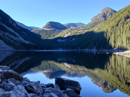
If you have the time and energy you can continue along the trail to visit the far end of the 47-acre lake. There are numerous places to stop and enjoy the views. To me, however, the best views are near the northern end, with the Spanish Peaks framing this rather large backcountry lake quite perfectly. Although its name might imply that volcanic forces were involved in its creation, the lake was actually formed by a landslide that dammed Cascade Creek between Jumbo Mountain and Table Mountain.
Additional Resources:
* Custer Gallatin National Forest website
* Lonely Planet Yellowstone & Grand Teton National Parks