Mount Glory
| Trail Features: | Outstanding Panoramic Views | 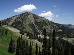 |
|||
| Trail Location: | Teton Pass | ||||
| Roundtrip Length: | 2.0 Miles | ||||
| Trailhead Elevation: | 8431 Feet | ||||
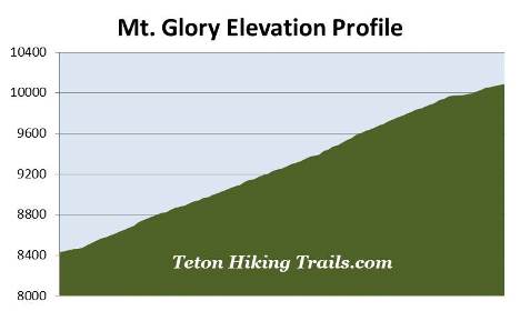
| Total Elevation Gain: | 1655 Feet | ||||
| Avg. Elev Gain / Mile: | 1655 Feet | ||||
| Highest Elevation: | 10,086 Feet | ||||
| Trail Difficulty Rating: | 5.31 (strenuous) | ||||
| Parking Lot Latitude | 43.49723 | ||||
| Parking Lot Longitude | -110.95538 | ||||
Trail Description:
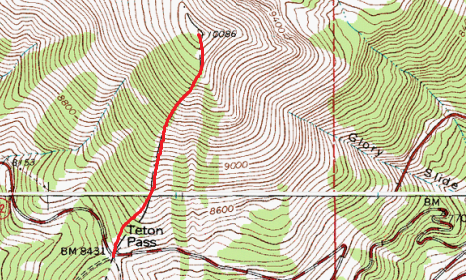
The hike to the summit of Mt. Glory begins from Teton Pass, located roughly 7 miles west of Wilson, WY, and 11.8 miles east of Victor, ID on WY 22. Although unmarked, the trailhead is easily spotted across the highway from the parking lot. Simply look for the yellow road sign that reads "25 MPH Curves Ahead / Next 3 Miles". You should definitely use caution while crossing the highway.
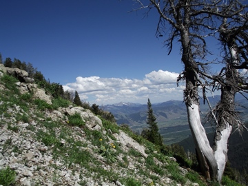 In case you didn't look closely at the summary trail data above, you should probably note that this hike is extremely steep. It gains a whopping 1655 feet in just one mile! With the exception of the saddle just below the summit, there are no places on the mountain to give your legs or lungs a break. To give you an idea on the steepness of the route, take a look at the photo on the right and compare the angle of the slope to the tree. The photo further down below was taken about a third of the way up the mountain.
Fortunately there's virtually no exposure to any steep drop-offs along the route, nor any places that require any scrambling. Moreover, the trail is surprisingly easy to follow. It's simply a matter of pushing yourself to proceed upward. You'll definitely want to be prepared for wind, sun, rain and even the possibility of snow. I would also definitely recommend bringing trekking poles, as they will provide support to your knees, and help prevent sliding on loose gravel on your way back down.
 Hikers should note that snow can linger on the mountain until July, which could make an ascent fairly dangerous for anyone without the proper equipment or snow skills. We climbed the mountain in late June and had no issues with snow; however, the Tetons experienced an unusually warm spring that year. July through September is usually the best time to tackle the mountain.
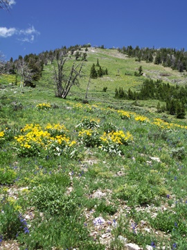
Mt. Glory is known for its spectacular wildflower displays, with peak wildflower season lasting between mid-July and early-August. During our late-June hike we saw a fair amount of wildflowers, though they were hard to enjoy while trying to suck-in the thin air.
The route to the summit straddles the boundary between the Caribou-Targhee National Forest and the Bridger-Teton National Forest. As you approach the top you'll notice several pieces of what appears to be old radio equipment. Once you reach this equipment you'll see what appears to be the highest point on the mountain. Unfortunately it's a false summit. After gaining this small saddle area you'll still have another 115 feet of climbing over the course of almost one-tenth of a mile to reach the actual summit.
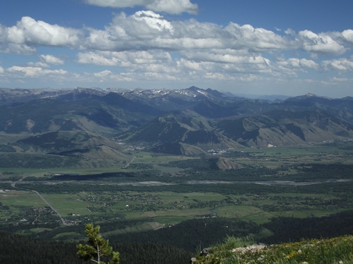
From the top of the peak hikers will be rewarded with some absolutely stunning views in all directions. Towards the east you'll have commanding views of Jackson Hole, the town of Jackson, the Snake River and the Gros Ventre Mountains. To the south will be the Snake River Range, and towards the north is the Teton Range.
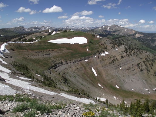
Towards the southeast, lying almost 3000 feet below the summit is Crater Lake. Just above Crater Lake is a bowl-shaped chute known as the Glory Bowl or the Glory Slide. According to an historical document on the U.S. Forest Service website, "Snow collects and slides down this bowl throughout the winter. A large avalanche can accumulate enough force to strip Crater Lake of accumulated ice, snow, and water - leaving the lake bed dry as it continues down the avalanche path…"
The first recorded ascent of Mt. Glory was made by Orestes St. John, the chief geologist for the Hayden Survey. St. John purportedly climbed the mountain on July 4th, 1877, which may have provided the inspiration for the naming of the mountain - after Old Glory.
For reference, it took us about an hour and 6 minutes to reach the top. We were probably a little slower than normal due to this being our first day at high elevation. Had we waited 2 or 3 more days we may have done a little better. Although we used trekking poles, descending was fairly slow going due to the small gravel on the path. It took us about an hour to return to Teton Pass.
Hikers should always be aware of lightning risk while hiking in the Grand Tetons, especially at higher elevations. As a general rule of thumb you should plan to turnaround before noon in order to avoid the notorious afternoon thunderstorms that frequent the mountains during the summer months. Hikers should also be prepared for extreme sun exposure, wind, cool temperatures, and rapidly changing weather conditions while on the trail. Make sure you have the proper gear with you, and know what safety precautions you need to consider beforehand.