Phelps Lake
| Trail Features: | Scenic Lake Views | 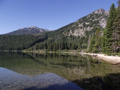 |
|||
| Trail Location: | Death Canyon Trailhead | ||||
| Roundtrip Length: | 4.7 Miles | ||||
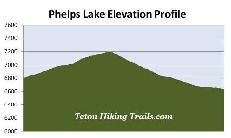
| Trailhead Elevation: | 6807 Feet | ||||
| Total Elevation Gain: | 965 Feet | ||||
| Avg. Elev Gain / Mile: | 411 Feet | ||||
| Highest Elevation: | 7200 Feet | ||||
| Trail Difficulty Rating: | 6.63 (moderate) | ||||
| Parking Lot Latitude | 43.65597 | ||||
| Parking Lot Longitude | -110.78128 | ||||
Trail Description:
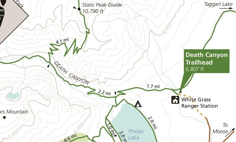
This hike to Phelps Lake in Grand Teton National Park begins from the Death Canyon Trailhead. To reach the trailhead from Moose Junction, turn left onto Moose-Wilson Road and drive roughly 3 miles south to reach the turn-off for the Death Canyon Trailhead. Turn right and drive another 2 miles to the end of the road. Although the first mile is paved, the last mile travels over a fairly rugged gravel road. The park highly recommends using a 4-wheel drive vehicle to reach the trailhead. At the point where the paved road ends there's a small parking area that allows people in 2-wheel drive vehicles to park and walk the last mile to the trailhead. Hikers also have the option of visiting the south shore of Phelps Lake from the Laurance S. Rockefeller Preserve.
The hike begins with a moderate climb through a forest dominated by lodgepole pines. Hikers will also pass a few aspen groves along the way as well. A short distance from the trailhead you'll reach the Valley Trail junction. Hikers should turn left onto the Valley Trail to continue towards Phelps Lake.
At exactly one mile hikers will arrive at the Phelps Lake Overlook. Resting at an elevation of 7200 feet, this perch stands 567 feet above Phelps Lake and offers outstanding panoramic views of the lake. While at the overlook take note of the old-growth Douglas firs nearby, some of which are estimated to be between 300 and 400 years old.
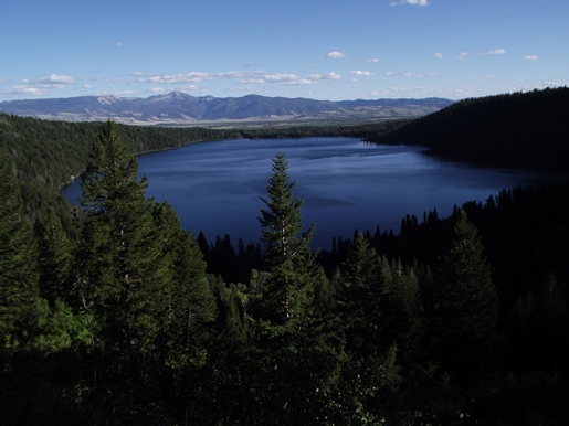
From the overlook the trail travels back down to the valley floor where you'll have access to the lakeshore. As the trail descends you'll enjoy additional views of the lake, as well as some outstanding views of the mouth of Death Canyon.
At just over 1.7 miles hikers will reach the Death Canyon Trail junction. Continuing straight at this junction will lead hikers into Death Canyon. To continue on towards the shore of Phelps Lake, hikers should turn left here.
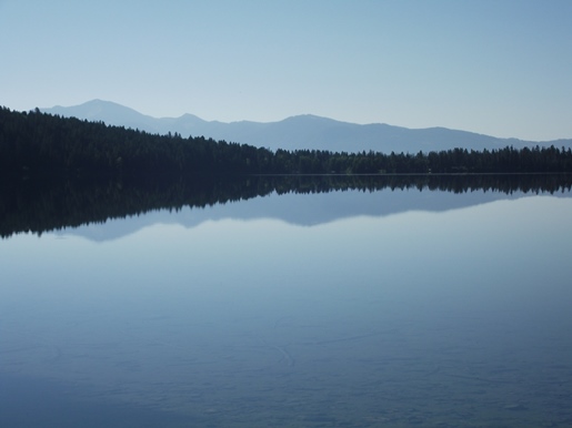
From the junction the Valley Trail continues for another three-tenths of a mile to reach the Phelps Lake Trail. Hikers should turn left here and continue for another third-of-a-mile to reach a small sandy beach area along the northern shore of Phelps Lake. Here you'll have some great views of the 750-acre, glacially-carved lake, the sixth largest lake in Grand Teton National Park.
From the beach the trail travels around Phelps Lake, and takes hikers through portions of the Laurance S. Rockefeller Preserve on the south side of the lake.
There are also three backcountry campsites located within the vicinity of the beach that offer backpackers relatively easy access to some great scenery.