Silver Run Plateau
| Trail Features: | Outstanding Views, Alpine Meadows, Flowers | 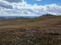 |
|||
| Trail Location: | Timberline Trailhead - Red Lodge, MT | ||||
| Roundtrip Length: | 12.1 Miles | ||||
| Trailhead Elevation: | 7625 Feet | ||||
| Total Elevation Gain: | 3010 Feet | ||||
| Avg. Elev Gain / Mile: | 498 Feet | ||||
| Highest Elevation: | 10,620 Feet | ||||
| Trail Difficulty Rating: | 18.12 (strenuous) | ||||
| Parking Lot Latitude | 45.17115 | ||||
| Parking Lot Longitude | -109.46406 | ||||
Trail Description:
This hike to the Silver Run Plateau in Custer Gallatin National Forest begins from the Timberline Trailhead near Red Lodge, Montana. To reach the trailhead, turn west onto West Fork Road on the south end of Red Lodge (look for a large sign indicating directions to Ski Area, West Fork Trails and West Fork Road). After traveling 2.7 miles you’ll turn/stay to the left to continue on West Fork Road. This junction is located just past the Custer National Forest sign. Though it appears to be the main road here, Ski Run Road actually branches off to the right and continues up the hill at this junction. At 4.5 miles the paved road turns into a gravel road, which is passable for two-wheel drive vehicles. At roughly 10.9 miles from the Beartooth Highway you’ll arrive at the Timberline Trailhead.
From the trailhead the Timberline Trail (#12) travels westbound for roughly six-tenths of a mile before reaching the Camp Senia Trail (#12.1) junction. Hikers should turn left here, at which point the trail makes a sharp switchback to continue up the hill.
Over the course of the first 1.25 miles or so the trail traverses along moderately strenuous terrain, at which point it eases considerably until reaching the Beartrack Trail. At 2.9 miles hikers will arrive at the Beartrack Trail junction. Almost immediately after turning left onto Beartrack Trail (#8) you’ll cross over Timberline Creek without the aid of a footbridge. If you wish to avoid getting your feet wet you’re going to have to use the makeshift log bridge that someone set-up here. This was a bit of a challenge during our trip, and likely will be for most hikers during the early and mid-summer months, or even later, depending on how high water levels are. Immediately after crossing the creek the trail begins climbing again.
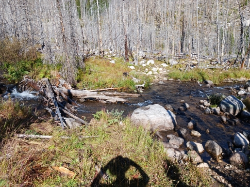
At 3.7 miles you’ll arrive at another creek crossing without the benefit of a footbridge. This crossing was also a bit of a challenge during our trip. Shortly thereafter you’ll reach the Absaroka-Beartooth Wilderness boundary.
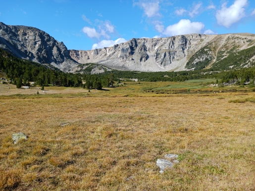
At roughly 4 miles the trail emerges onto a beautiful meadow. As you continue walking up the meadow you’ll reach an absolutely gorgeous basin known as the Silver Run Lakes Basin, which features at least three lakes or tarns, and is surrounded by towering mountains and ridgelines on three sides.
From the basin the trail continues by passing through a wooded area. Up to this point the vast majority of the hike traverses through open terrain, mostly the result of the 2008 Cascade Fire. Though this isn’t the most appealing environment to hike through, the scenic meadows and the expansive alpine basin definitely makes this a worthy hike.
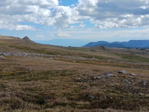
From the basin floor the trail begins to climb the southeastern wall of the Silver Run Plateau, all the while passing in and out of pine stands. At roughly 4.9 miles the trail finally emerges from the trees for the final time. At this point you’ll enjoy commanding views of the broad basin below.
Although there’s not a clear demarcation of a transition, by roughly 5.4 miles the trail reaches the top of the basin wall where you’ll begin ascending along the plateau. At this point you’ll be hiking in alpine tundra, and therefore will be exposed to all the elements, including fast approaching storms, intense sun and wind. It’s best to be prepared for all types of weather on this hike.
At roughly 5.6 miles the trail begins to disappear into the tundra. From this point forward you’ll be following cairns to reach the summit. Up to this point the trail has been well defined, and very easy to follow. Additionally, there’s virtually no exposure to any steep drop-offs. The cairns along the plateau are also clearly visible and easy to follow.
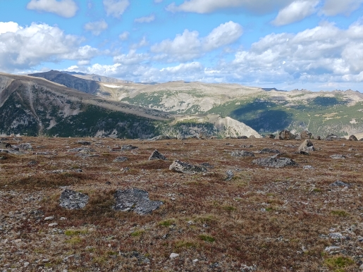
At just over 6 miles, and an elevation of roughly 10,620 feet, hikers will finally reach the top of the Silver Run Plateau on this hike. However, I would recommend walking at least another tenth-of-a-mile or so to attain a much better view of the expansive mountainous terrain on the east side of the plateau.
Finally, you should note that this trail also travels through bear country, so be sure to bring bear spray, and know how to use it.
Additional Resources:
* Custer Gallatin National Forest website
* Lonely Planet Yellowstone & Grand Teton National Parks