String Lake Loop
| Trail Features: | Outstanding Lake Views, Panoramic Views | 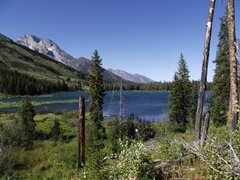 |
|||
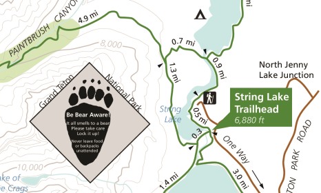
| Trail Location: | String Lake Trailhead | ||||
| Roundtrip Length: | 3.8 Miles | ||||
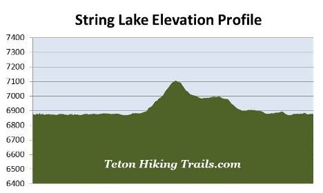
| Trailhead Elevation: | 6875 Feet | ||||
| Total Elevation Gain: | 275 Feet | ||||
| Avg. Elev Gain / Mile: | 145 Feet | ||||
| Highest Elevation: | 7105 Feet | ||||
| Trail Difficulty Rating: | 4.35 (easy) | ||||
| Parking Lot Latitude | 43.78467 | ||||
| Parking Lot Longitude | -110.72727 | ||||
Trail Description:
The String Lake Loop in Grand Teton National Park begins from the String Lake Trailhead, located just north of Jenny Lake. To reach the trailhead, turn west off Teton Park Road at the North Jenny Lake Junction, located roughly 10.6 miles north of Moose Junction, and 10 miles south of Jackson Lake Junction. Continue for another 1.4 miles to the turn-off for the String Lake Trailhead. After turning right, the trailhead parking area will be on your immediate left.
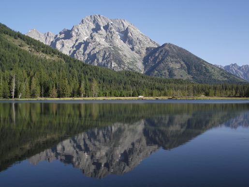
Although you can begin your hike in either direction, we chose to proceed in a counter-clockwise direction so that we could enjoy the best views of the mountains above String Lake during the early morning light.
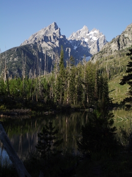 From the trailhead the loop trail proceeds north along the eastern shore of String Lake. Outstanding views of the "Cathedral Group," which includes 12,325-foot Teewinot Mountain, 13,770-foot Grand Teton and 12,928-foot Mt. Owen, will appear almost immediately. Mt. Moran will provide as the perfect scenic backdrop against the lake roughly one-half mile past the trailhead.
Portions of the hiking trail are paved as you proceed along this first stretch of the hike, with a few interpretative signs along the way that explain how glaciation created the chain of lakes below the Teton Range.
At just under six-tenths of a mile you'll pass the Leigh Lake Trailhead. From here the trail continues to follow along the eastern shore of the narrow lake. Hikers will pass several vantage points that offer exceptional views of Mt. Moran as they proceed northward.
At 12,605 feet, Mt. Moran is the fourth highest mountain in Grand Teton National Park. It's named for artist Thomas Moran whose landscape paintings were critical to the creation of Yellowstone National Park. The mountain was also the site of a tragic airplane crash. On November 21, 1950, a C-47 cargo plane owned by the New Tribes Mission crashed into the peak during a thunderstorm, killing all 21 missionaries on board. Although a rescue party was able to locate the wreckage several days later, the precarious position of the crash made it impossible to recover the plane or its victims.
At roughly 1 mile you'll pass the String Lake Horse Trail, which branches off to the right. Hikers should proceed straight ahead to continue on the loop.
At just under 1.4 miles you'll arrive at the Bearpaw Lake Trail junction, which also branches off to the right. This trail leads hikers along the eastern shore of Leigh Lake, and eventually up to Bearpaw Lake. To continue on the loop around String Lake hikers should veer to the left and head towards the Paintbrush Canyon Trail.
A short distance beyond the junction the trail crosses over the Leigh Lake Outlet. Although the sign near this crossing is somewhat confusing, you should turn left and walk across the footbridge.
From the footbridge the trail travels away from the lake and begins a moderate climb through a lodgepole pine forest. At just over 2.1 miles it will reach the top of the climb at the Paintbrush Canyon Trail junction. The trail heading up the switchback on the right continues towards Paintbrush Canyon, and eventually on to Holly Lake, while the trail proceeding straight ahead continues the loop around String Lake.
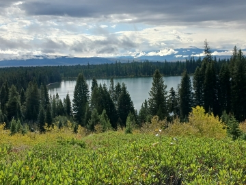 As you proceed back down towards the lake hikers will emerge into the open once again, and will begin passing through an avalanche zone. This section of trail travels through a fairly large area with numerous aspens that have been snapped off roughly five or six feet above the ground. The recent avalanches have resulted in hikers having better views of String Lake in the valley below.
At 3.5 miles you'll reach the Jenny Lake Trail junction. A turn to the right would put hikers on the loop around Jenny Lake. To continue back towards the String Lake Trailhead hikers should turn left here.
At roughly 3.75 miles hikers will arrive at the footbridge spanning the String Lake Outlet. After crossing the bridge you should turn left to return back to the trailhead, which is roughly one hundred yards away from this point.
This loop is an excellent choice for anyone looking for an easy hike, especially in the mornings when the mountains are reflecting in the lake. You'll also have a great chance of spotting a variety of wildlife, such as moose or mule deer. The combination of outstanding scenery and the variety of wildlife easily places this on my list of the best hikes in Grand Teton National Park.