Bearpaw Lake
| Trail Features: | Panoramic Views, Lake Views | 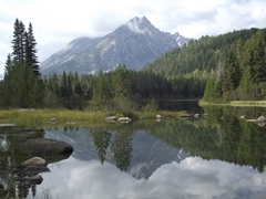 |
|||
| Trail Location: | Leigh Lake Trailhead | ||||
| Roundtrip Length: | 7.8 Miles | ||||
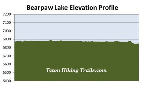
| Trailhead Elevation: | 6875 Feet | ||||
| Total Elevation Gain: | 110 Feet | ||||
| Avg. Elev Gain / Mile: | 28 Feet | ||||
| Highest Elevation: | 6892 Feet | ||||
| Trail Difficulty Rating: | 8.02 (moderate) | ||||
| Parking Lot Latitude | 43.78826 | ||||
| Parking Lot Longitude | -110.7313 | ||||
Trail Description:
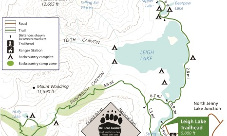
The hike to Bearpaw Lake begins from the Leigh Lake Trailhead, located just north of Jenny Lake. To reach the trailhead turn west off Teton Park Road at the North Jenny Lake Junction, located roughly 10.6 miles north of Moose Junction, and 10 miles south of Jackson Lake Junction. Drive another 1.4 miles to the turn-off for the String Lake and Leigh Lake trailheads. After turning right, continue for another 0.4 miles to the Leigh Lake Trailhead at the far end of the road.
From the parking area walk down along the short paved path to String Lake where you'll immediately reach the Valley Trail, also known as the String Lake Loop Trail. Once on the footpath, turn right and begin heading north along the eastern shore of String Lake.
I highly recommend starting your hike as early as possible for the best views of the mountains above String and Leigh Lakes during the early morning light. From the trailhead you'll enjoy exceptional views of 12,325-foot Teewinot Mountain and 11,144-foot Rockchuck Peak. As you proceed along the shores of String Lake you'll also be treated to some absolutely stunning views of Mt. Moran.
At 12,605 feet, Mt. Moran is the 4th highest mountain in Grand Teton National Park. It's named for artist Thomas Moran whose landscape paintings were critical to the creation of Yellowstone National Park. The mountain was also the site of a tragic airplane crash. On November 21, 1950, a C-47 cargo plane owned by the New Tribes Mission crashed into the peak during a thunderstorm, killing all 21 missionaries on board. Although a rescue party was able to locate the wreckage several days later, the precarious position of the crash made it impossible to recover the plane or its victims.
At one-half mile from the trailhead hikers will pass the String Lake Horse Trail, which branches off to the right. At almost nine-tenths of a mile you'll reach the Bearpaw Lake Trail split. The trail leading towards the left circles around String Lake. Hikers should turn right at this junction to continue towards Leigh Lake and Bearpaw Lake.
A short distance beyond this fork you'll reach the Leigh Lake portage trail, which branches off towards the left. You should veer to the right at this junction to continue towards the two lakes.
At roughly one mile from the trailhead hikers will arrive at an unmarked junction. The path leading to the left connects with the Leigh Lake portage trail. It also provides a few access points to the lake's south shore. To continue towards Bearpaw Lake you should proceed straight ahead at this junction.
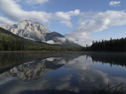
Unlike String Lake, access to Leigh Lake is relatively sparse. There are really only a few spots where you can easily reach the lakeshore for great views. One such spot is just past the 1.8-mile mark. This small rocky beach offers outstanding views of the middle portions of the Teton Range, which includes 12,325-foot Teewinot Mountain, 11,144-foot Rockchuck Peak, 11,590-foot Mt. Woodring and Mt. Moran, looking from left to right.
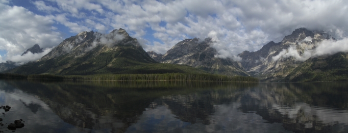
Hikers will enjoy a similar view near the Leigh Lake backcountry campsite area, located roughly 2.3 miles from the trailhead. Along this series of campsites hikers will have access to a fairly long sandy beach area. In fact, if you're a backpacker, these sites are among the premier backcountry campsites in the entire park.
Leigh Lake is the third largest lake in the Tetons, and with a maximum depth of 250 feet, is also one of the deepest. It was named by Ferdinand Hayden during his 1872 expedition for Richard "Beaver Dick" Leigh, an itinerant trapper who helped guide the expedition through this area. Nearby Jenny Lake was named for his wife, a Shoshone Indian who assisted with camp logistics. In 1876 Jenny and their six children died of smallpox.
At roughly 2.75 miles hikers will begin passing through the outskirts of an area that was burned during the Bearpaw Bay Fire. This lightning-ignited wildfire charred more than 2900 acres between Leigh Lake and Jackson Lake in September of 2009. Strangely, the trail appears to have acted as a barrier. While much of the terrain on the east side of the trail has been burned, the lake side has little or no evidence of being burned at all.
 At roughly 3.1 miles the trail veers away from Leigh Lake, and begins heading towards Bearpaw Lake. A half-mile later you'll reach a large meadow that offers decent views of Rockchuck Peak and Mt. Woodring. Soon afterwards you'll reach another split in the trail. The left fork travels up to Trapper Lake, while the right fork continues towards Bearpaw Lake.
Shortly after passing the junction the trail drops down towards Bearpaw Lake. As the trail proceeds along the east side of the lake you'll notice a couple of spots along the way that provide access points to the shore. Although the views are decent in these areas, we thought the views from the north end of the lake were the best. At roughly 3.9 miles, just before reaching the Bearpaw Lake backcountry campsite, look for a faint side trail that provides access near the northeastern corner of the lake.
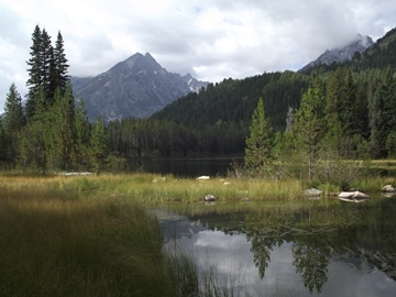
Bearpaw Lake isn't nearly as large or scenic as Leigh Lake or String Lake, but it does offer some pleasant views, as well as a degree of solitude in this extremely popular area of the park. Much of the lake is surrounded by grassy wetlands, making this a great place to spot a variety of wildlife, such as waterfowl or mule deer. Directly across the lake are the lower slopes of Mt. Moran, while the mountain peak just to its left is Mt. Woodring. The prominent mountain towards the south is Rockchuck Peak.