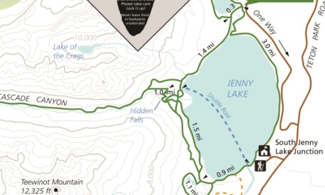
Jenny Lake Loop
| Trail Features: | Panoramic Views, Lake Views | 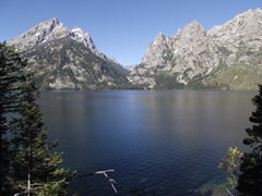
|
|||
| Trail Location: | Jenny Lake Trailhead | ||||
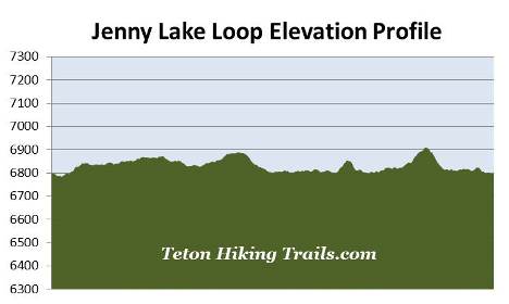
| Roundtrip Length: | 7.5 Miles | ||||
| Trailhead Elevation: | 6800 Feet | ||||
| Total Elevation Gain: | 275 Feet | ||||
| Avg. Elev Gain / Mile: | 73 Feet | ||||
| Highest Elevation: | 6910 Feet | ||||
| Trail Difficulty Rating: | 8.05 (moderate) | ||||
| Parking Lot Latitude | 43.75114 | ||||
| Parking Lot Longitude | -110.7238 | ||||
Trail Description:
The Jenny Lake Loop in Grand Teton National Park begins from the Jenny Lake Trailhead. To reach the trailhead turn west off Teton Park Road at the South Jenny Lake Junction, located roughly 7.7 miles north of Moose Junction. From the junction drive another half-mile to the large parking area for the visitor center and boat dock.
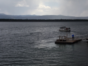
From the Jenny Lake parking area follow the paved path down to the boat dock to access the loop trail around the lake. Although you can begin your hike in either direction, this description follows the route in a counter-clockwise direction. We chose this course because the lighting on the mountains towards the west will be much better during the early part of the day, rather than later.
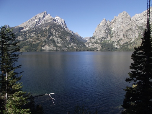
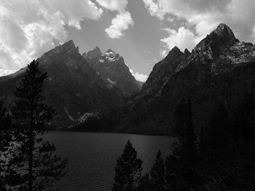
From the East Boat Dock area the hike begins by following along the eastern shore of Jenny Lake. The terrain along this side of the lake is mostly forested, and fairly flat. However, there are a couple of short, small hills that hikers will have to traverse, but nothing exceedingly strenuous. For the most part the footpath stays relatively close to the shoreline, and provides numerous vantage points along the way that offer stunning views of Teewinot Mountain, Mt. Owen, Cascade Canyon, Storm Point, Symmetry Spire, Mt. St. John, Rockchuck Peak and Mt. Moran.
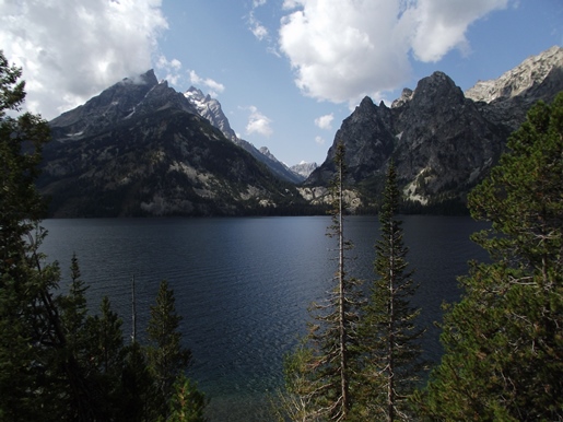
Covering roughly 1191 acres, glacially-carved Jenny Lake is the second largest lake in Grand Teton National Park. At 423 feet it's also one of the deepest. The lake was named for a Shoshone Indian named Jenny who assisted with camp logistics during the Hayden Geological Survey of 1872. Nearby Leigh Lake is named for her husband, Richard "Beaver Dick" Leigh, an itinerant trapper who helped guide the Hayden Expedition through the area. In 1876 Jenny and their six children died of smallpox.
Unfortunately, a fairly long section of the Jenny Lake Scenic Road passes fairly close to the eastern portion of the trail, which means you'll likely have quite a bit of road noise along this stretch of trail. In addition to avoiding the crowds in this extremely popular area of the park, this is another good reason to begin your hike as early in the morning as possible.
At roughly 2.4 miles you'll begin passing through a fairly large area that was burned during the Alder Fire. This lightning-ignited fire scorched 391 acres along the northern portions of the lake in September of 1999.
At 2.6 miles you'll reach the String Lake Outlet. Hikers will have to travel more than a half-mile upstream in order to cross the footbridge over this waterway, which connects String Lake with Jenny Lake. Once across the footbridge the trail returns back to Jenny Lake.
 At 3.4 miles hikers will arrive at the Jenny Lake Trail junction. The loop around String Lake continues towards the right. To stay on the loop around Jenny Lake you should proceed straight ahead here.
Soon the trail returns back to the northwestern shore of Jenny Lake. Much of this portion of the route travels through open terrain, mainly due to the 1999 wildfire. This side of the lake also offers great views of the Gros Ventre Mountains towards the east.
As you get closer to the West Shore Boat Dock area the trail re-enters the forest once again. This section of trail also passes through some fairly long stretches of thimbleberries. Hikers should keep an eye out for black bears throughout the western portions of this loop.
At just over 4.7 miles hikers will pass a horse trail branching off to the right. Two-tenths of a mile later you'll reach the West Shore Boat Dock, and will now be on the same trail that leads hikers to Hidden Falls and Inspiration Point. You'll likely be sharing this portion of the route with several other fellow hikers who are visiting these extremely popular destinations.
The Spring 1939 issue of Grand Teton Nature Notes reports that "By far the most popular trail in the park is the lower portion of the Cascade Canyon Trail which leaves Jenny Lake and climbs above Hidden Falls." More than 80 years later that statement still holds true. As a result of overuse through the years, the park launched a multi-year project to improve the area surrounding Jenny Lake in 2014. The project included extensive rehabilitation of trails connecting Hidden Falls and Inspiration Point, as well as improvements to the viewing areas at both destinations.
 At 5.1 miles you'll reach the Jenny Lake Trail junction. The trail to the right proceeds up to Hidden Falls and Inspiration Point. Both destinations are well worth the side trip if you have the time and energy. To continue on the loop, hikers should turn left and proceed across the footbridge over Cascade Canyon Creek.
A short distance beyond Cascade Canyon Creek hikers will pass another horse trail. To continue towards the West Shore Boat Dock area you should veer to the left at this junction.
Although much of the southwestern portion of the loop travels through heavily forested terrain, there are still many breaks in the canopy that offer sweeping views of the lake and surrounding mountains.
At roughly 6.4 miles you'll reach the Hidden Falls Horse Trail, which leads back to the Inspiration Point area. To continue on the loop you should stay to the left here. A short distance beyond the junction the trail reaches a small clearing that overlooks Moose Ponds. Just down the hill is a short side trail that leads to the two ponds, an area that offers hikers an excellent opportunity for spotting a moose.
From the Moose Ponds area the trail makes a beeline towards the southern tip of Jenny Lake. A Civilian Conservation Corps (CCC) camp once stood in this area. The camp was built in 1934, and was occupied through 1942 as part of President Franklin D. Roosevelt's New Deal. Among its many accomplishments and responsibilities, the CCC constructed the Jenny Lake Trail during this period.
At just over 6.6 miles hikers will reach the Valley Trail junction. To continue towards the trailhead hikers should veer to the left here. At roughly 7.1 miles you'll pass the boat launch area, and at 7.3 miles will reach the footbridge at the East Boat Dock. Just after crossing the footbridge you'll immediately make a right turn to return back to the parking area.