Taggart Lake-Beaver Creek Loop
| Trail Features: | Panoramic Views, Lake Views, Wildlife | 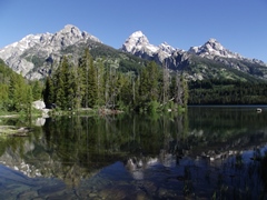 |
|||
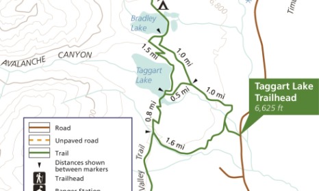
| Trail Location: | Taggart Lake Trailhead | ||||
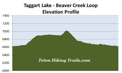
| Roundtrip Length: | 3.8 Miles | ||||
| Trailhead Elevation: | 6625 Feet | ||||
| Total Elevation Gain: | 425 Feet | ||||
| Avg. Elev Gain / Mile: | 224 Feet | ||||
| Highest Elevation: | 7020 Feet | ||||
| Trail Difficulty Rating: | 4.65 (easy) | ||||
| Parking Lot Latitude | 43.69313 | ||||
| Parking Lot Longitude | -110.73299 | ||||
Trail Description:
The Taggart Lake-Beaver Creek Loop hike begins from the Taggart Lake Trailhead, located roughly 2.3 miles north of the Moose Entrance Station. This hike visits Taggart Lake, before looping around towards the south and trekking alongside Beaver Creek for a short distance.
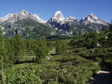
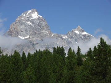
From the trailhead hikers will immediately enjoy stunning views of Grand Teton towering above the sagebrush flat. At 13,770 feet, Grand Teton is the highest mountain in the Teton Range. The peak was renamed as Mt. Hayden by the 1872 Hayden Geological Survey, but most people continued to call it Grand Teton Peak. In 1931 the U.S. Board of Geographic Names recognized its more common name, and then shortened it to Grand Teton in 1970.
 The first documented ascent of the peak occurred on August
11, 1898 by four climbers. Two members of the Hayden Geological Survey claimed to have reached the summit on July 29, 1872. However, that ascent is disputed by climbers and historians who have concluded, after studying the climber's accounts, that the two reached a side peak known as The Enclosure. Moreover, the 1898 climbers found no evidence of a previous ascent, including a cairn which was a common practice for the expedition.
The first documented ascent of the peak occurred on August
11, 1898 by four climbers. Two members of the Hayden Geological Survey claimed to have reached the summit on July 29, 1872. However, that ascent is disputed by climbers and historians who have concluded, after studying the climber's accounts, that the two reached a side peak known as The Enclosure. Moreover, the 1898 climbers found no evidence of a previous ascent, including a cairn which was a common practice for the expedition.
At just over one-tenth of a mile from the trailhead hikers will reach a fork in the trail. Although you can hike this loop in either direction, we chose to hike in a counter-clockwise direction. The Beaver Creek Trail leads towards the left. For purposes of this trail description you should veer to the right to remain on the Taggart Lake Trail.
After walking another tenth-of-a-mile you'll arrive at another split where an old gravel road forks off to the left. Hikers should remain on the footpath that leads to the right to continue on towards Taggart Lake. A short distance beyond the junction you'll cross a footbridge over Taggart Creek which offers a nice view of a cascading waterfall just upstream from the bridge.
At just over four-tenths of a mile hikers will pass the NPS horse corrals. Soon afterwards the trail begins climbing a moderate grade towards Taggart Lake. This section of trail more or less follows along Taggart Creek, while traveling through a mixed forest of spruce, fir and lodgepole pine. You'll also pass through some long stretches of aspen groves, making this an excellent choice for a fall hike.
At just over a mile from the trailhead you'll begin passing through an area that was burned during the 1985 Beaver Creek Fire. The lightning-ignited wildfire charred more than 1000 acres, and was reported to be so intense that it "exfoliated 8 to 10 cm of stone from granite boulders". As a result, hikers now have excellent opportunities for spotting a wide variety of wildlife that are now taking advantage of the new growth, as well as the decaying trees. This will include mountain bluebirds, flycatchers, woodpeckers, owls, marmots, elk, mule deer and bears. Throughout this stretch hikers will also enjoy outstanding views of the mountains looming towards the west.
At just over 1.1 miles hikers will arrive at the Bradley Lake Trail junction. The trail leading to the right visits Bradley Lake, the smallest of the glacially-carved chain lakes lying below the Teton Range. To continue directly towards Taggart Lake, hikers should veer to the left at this junction.
From the junction the trail travels over mostly level terrain that also offers some amazing mountain scenery. After walking only a half-mile you'll finally reach the southeastern shore of Taggart Lake where you'll enjoy outstanding views of 12,804-foot Middle Teton, Garnet Canyon, Grand Teton, 12,928-foot Mt. Owen and 12,235-foot Teewinot Mountain.
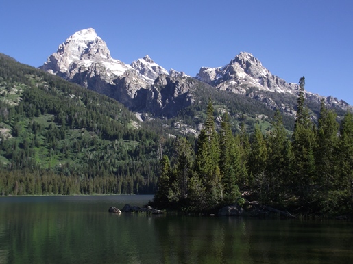
This 305-acre, glacially-carved lake was named for William Rush Taggart, an assistant geologist under Frank Bradley during the Hayden Geological Survey of 1872. Both Taggart and Bradley were among the party that attempted to climb Grand Teton during that expedition.
After soaking in the outstanding scenery at the lake, hikers should return to the main trail. From here you'll turn right onto the Valley Trail and begin heading in southerly direction.
In a little over a tenth-of-a-mile the trail crosses a footbridge over a narrow point on Taggart Lake. On the other side you'll begin a short, but fairly steep climb over a glacial moraine. From the top of the ridge you'll have some great views looking towards the southern portions of Jackson Hole.
 At just over 2.4 miles the trail reaches Beaver Creek, and almost immediately afterwards you'll arrive at the Beaver Creek Trail junction. To continue on the loop hikers should veer left onto the Beaver Creek Trail.
As you proceed down the valley you'll pass through grassy meadows and sections of old growth pine forest. Portions of the creek on your right will be choked with willows, making this an excellent area to possibly spot a moose. You could also see elk and deer, and maybe even a black bear as you pass through this stretch.
Eventually the path leads away from Beaver Creek and begins tracking towards the east. Along this portion of the hike you'll have some pretty good views of Jackson Hole. As you continue you'll also enjoy some great views of Grand Teton once again.
At roughly 3.75 miles you’ll reach a triangular trail junction. Hikers should turn to the right to begin heading back towards the trailhead. A short distance later you'll reach the beginning of the loop portion of the hike. From this junction hikers should retrace their steps back to the trailhead, which is now just over a tenth-of-a-mile away.