Black Canyon Overlook
| Trail Features: | Outstanding Views, Wildflowers | 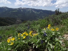 |
|||
| Trail Location: | Teton Pass | ||||
| Roundtrip Length: | 3.7 Miles | ||||
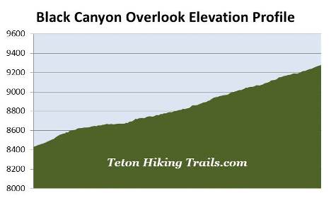
| Trailhead Elevation: | 8431 Feet | ||||
| Total Elevation Gain: | 848 Feet | ||||
| Avg. Elev Gain / Mile: | 458 Feet | ||||
| Highest Elevation: | 9279 Feet | ||||
| Trail Difficulty Rating: | 5.40 (moderate) | ||||
| Parking Lot Latitude | 43.49723 | ||||
| Parking Lot Longitude | -110.95538 | ||||
Trail Description:
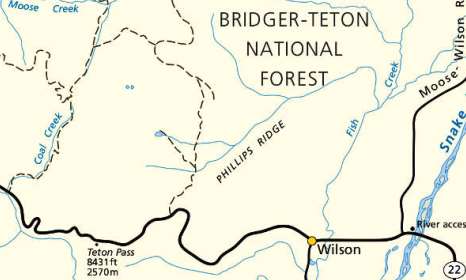
The hike to Black Canyon Overlook (also referred to as Mount Elly Overlook) begins from Teton Pass, located roughly 7 miles west of Wilson, WY, and 11.8 miles east of Victor, ID on WY 22.
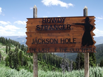 Hikers may want to note that there are two routes that lead to Black Canyon Overlook. On the west side of the pass is an informational kiosk, which appears to be a trailhead sign. This route is actually a service road, which eventually links up with the Black Canyon Trail. The more scenic Black Canyon Trail itself begins towards the east side of the pass, near the famous "Howdy Stranger / Jackson Hole" sign. Hikers should head south along this unmarked path.
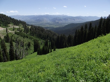
The hike begins with a moderate climb as the trail skirts along the eastern side of Pass Ridge. Although the grade is fairly moderate, the altitude can make this route a little challenging. During this stretch hikers will enjoy outstanding views of Jackson Hole and the Gros Ventre Range. The dominating feature across the highway is 10,086-foot Mt. Glory.
The route to the overlook straddles the boundary between the Caribou-Targhee National Forest and the Bridger-Teton National Forest. There are a couple of sections near the start where the trail passes over some rather steep drop-offs. For those who have a fear of heights, or have small children, simply take your time and you shouldn't have any issues. The service road bypasses this section if you wish to avoid it. With its close proximity to the town of Jackson, hikers should also note that they may be sharing the trail with mountain bikers.
 As we traveled along the route during our late-June hike we enjoyed several varieties of wildflowers blooming along the hillside, including arrow-leaf balsamroot, lupine and several Colorado columbines. Peak wildflower season in the Teton Pass area usually occurs from mid-July through early-August. Hikers may also find mountain bog gentian, harebell, low larkspur, ballhead sandwort, Whipple's penstemon and mountain bluebell growing in the meadows and along the hillsides.
At roughly one-third of a mile from the trailhead you'll round a sharp bend and will immediately notice the radio and powerline towers just up the trail. At one-half mile the trail reaches the aforementioned service road. Hikers should continue by heading left and traveling under the power line. Once past the tower you'll easily pick up the trail again.
At just under 1.6 miles hikers will reach a short spur trail that leads to an overlook of Jackson Hole. This shouldn't be confused with Black Canyon Overlook, which is still another quarter-of-a-mile away.
At just over 1.8 miles hikers will reach Black Canyon Overlook, which is actually the summit of 9279-foot Mt. Elly. A small sign marks the overlook in case there's any confusion. From this scenic vantage point you'll enjoy commanding views of Black Canyon and the Snake River Range lying towards the south and southeast.
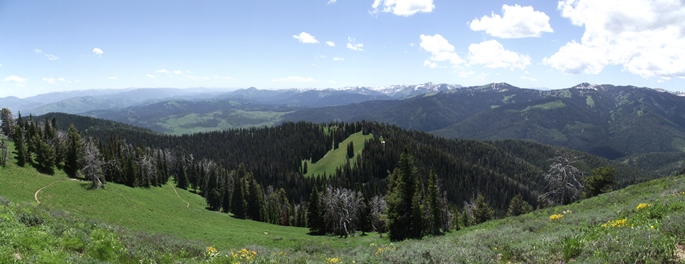
From the overlook the Black Canyon Trail makes a rapid descent towards Trail Creek Road near Wilson. If you have two cars in your group you could create a one-way hike of roughly six miles between the two trailheads.
Hikers should also note that the majority of the route to Black Canyon Overlook is exposed to sun, wind and rain.