Paintbrush Canyon - Cascade Canyon Loop
| Trail Features: | Panoramic Views, Lakes, Wildflowers | 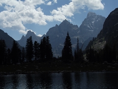 |
|||
| Trail Location: | Leigh Lake Trailhead | ||||
| Roundtrip Length: | 19.7 Miles | ||||
| Trailhead Elevation: | 6875 Feet | ||||
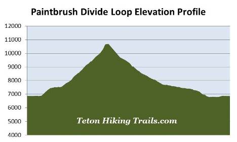
| Total Elevation Gain: | 3975 Feet | ||||
| Avg. Elev Gain / Mile: | 404 Feet | ||||
| Highest Elevation: | 10,700 Feet | ||||
| Trail Difficulty Rating: | 27.65 (strenuous) | ||||
| Parking Lot Latitude | 43.78826 | ||||
| Parking Lot Longitude | -110.7313 | ||||
Trail Description:
The Paintbrush Canyon-Cascade Canyon Loop is an epic hike, in terms of both scenery and in total mileage. Although many people choose to do this hike in two, or even three days, many others attempt to do it in one long day. Either way, hikers should be prepared for a wide variety of weather conditions, including sun, wind, snow and thunderstorms. Hikers should plan accordingly by starting their hikes early enough in order to avoid the notorious afternoon thunderstorms, and subsequent lightning risk, while hiking in exposed areas, especially near Paintbrush Divide. In short, weather conditions can change rapidly in Grand Teton National Park.
Hikers should note that snow and ice can linger at the higher elevations of this route into August. Early season hikers should check with a ranger on trail conditions before attempting this loop.
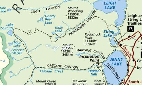
This description of the Paintbrush Canyon-Cascade Canyon Loop hike begins from the Leigh Lake Trailhead, located just north of Jenny Lake. To reach the trailhead turn west off Teton Park Road at the North Jenny Lake Junction, located roughly 10.6 miles north of Moose Junction, and 10 miles south of Jackson Lake Junction. Drive another 1.4 miles to the turn-off for the String Lake and Leigh Lake trailheads. After turning right, continue for another 0.4 miles to reach the Leigh Lake Trailhead at the end of the road. If you have two vehicles in your group you'll also have the option of taking the shuttle boat across Jenny Lake which would cut-off almost one-and-a-half miles, making this an 18.3-mile hike instead of 19.7 miles. This option travels in a clockwise direction, thus taking you through Cascade Canyon first. There is a fee for the boat ride
.From the Leigh Lake parking area walk down along the short paved path to String Lake where you'll immediately reach the Valley Trail, also known as the String Lake Loop Trail. Once on the path turn right and begin heading north along the eastern shore of String Lake. Although you can hike this loop in either direction, most people choose to hike it in a counter-clockwise direction, thus passing through Paintbrush Canyon first. The consensus opinion is that this direction offers the best views as the sun progresses across the sky. Moreover, if you were to run into problems with weather or snow near Paintbrush Divide, this route would allow you to turn around and return to the trailhead faster.
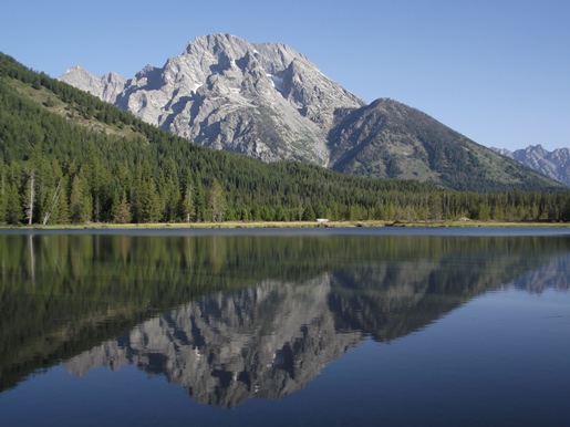 From the trailhead hikers will enjoy great views of 12,325-foot Teewinot Mountain and 11,144-foot Rockchuck Peak. As you proceed along the shores of String Lake you'll also be treated to some absolutely stunning views of Mount Moran. At 12,605 feet Mount Moran is the fourth highest mountain in Grand Teton National Park. It's named for artist Thomas Moran whose landscape paintings were critical to the creation of Yellowstone National Park.
At one-half mile from the trailhead hikers will pass the String Lake Horse Trail, which branches off to the right. Hikers should proceed straight ahead at this junction and continue towards Holly Lake.
At almost nine-tenths of a mile hikers will reach the Bearpaw Lake Trail, which branches off towards the right. To continue on towards Paintbrush Divide hikers should veer to the left and proceed towards the Paintbrush Canyon Trail. A short distance from the junction the trail crosses over the Leigh Lake Outlet. Although the trail sign at this junction is a little confusing, you should turn left and cross the footbridge.
From the footbridge the trail skirts away from the lake and begins making a moderate climb through a lodgepole pine forest. At almost 1.6 miles it reaches the Paintbrush Canyon Trail junction. The trail continuing straight ahead resumes the loop hike around String Lake, while the trail leading up the switchback on the right continues towards Paintbrush Canyon. Hikers should turn right here to continue on towards Holly Lake.
At roughly 3 miles from the trailhead, near the mouth of Paintbrush Canyon, you'll begin passing through an extremely long stretch of huckleberries, which will go on almost continuously for the next mile or so. You'll definitely want to make a lot of noise as you pass through this section of trail. In grizzly country it's always a good idea to travel in groups of at least three people. You should also carry bear spray, and know how to use it.
At roughly 3.9 miles the trail crosses over Paintbrush Canyon Creek, and shortly thereafter emerges into open terrain. Here you'll enjoy some great views into Paintbrush Canyon. This valley is known for its outstanding wildflower displays, including blue columbine, Indian paintbrush and mountain gentian.
 As the trail climbs the creek will now be on your left side, but for the most part will be hidden by willows. This is likely a very good place to spot moose. As you proceed higher the trail also passes through several long sections of chest high vegetation. You'll definitely want to make a lot of noise and be "bear aware" throughout this area as well.
At roughly 4.4 miles you'll reach a very short section of trail that was damaged by a flash flood. Above this zone the trail begins passing through a large boulder field. The route itself also becomes fairly strenuous, and traverses over fairly rocky and rugged terrain. Though not necessary, trekking poles may be helpful along this stretch.
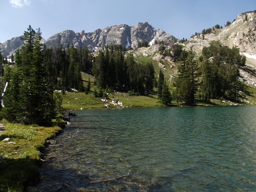
At roughly 6 miles hikers will reach the Holly Lake junction. Both trails reconnect further up-trail before continuing to Paintbrush Divide. Since the trail to the right is slightly shorter, and passes two alpine lakes, hikers should turn right here and proceed towards Holly Lake. Just beyond the junction the trail passes the first lake, which is actually a small tarn. Though it takes a little bit of effort to reach the tarn, the views of the divide from the shore area are outstanding. Hikers should note that it can be fairly marshy around the tarn, so access may be limited depending on your timing.
At 6.5 miles hikers will arrive at Holly Lake. This small glacial lake lies just below the southern slopes of 11,590-foot Mt. Woodring. Directly to the west is Paintbrush Divide, while looking towards the east you'll be able to see 11,144-foot Rockchuck Peak. Once at the lake we recommend heading off towards the right and proceeding a short distance along a faint social trail that leads to the east end of the lake. The views of the mountains surrounding the lake, including the Paintbrush Divide area, are much better from this vantage point.
Once past Holly Lake the trail rejoins the Paintbrush Canyon Trail and continues climbing through the upper canyon. Before reaching Paintbrush Divide the trail crosses over a scree field and circles around a couple of permanent snow fields. During the early hiking season these snowfields may still be covering portions of the trail. As you proceed higher there are a couple of short sections that pass along narrow ledges with exposure to steep drop-offs. Additionally, since this area is known for high winds, you may want to consider bringing trekking poles for this stretch.
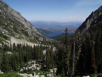
At roughly 8.2 miles hikers will finally reach Paintbrush Divide. At 10,700 feet, this is one of the highest points you can reach on a maintained trail in Grand Teton National Park. From the Divide hikers will enjoy incredible 360-degree views. You'll rnjoy commanding views of Thor Peak, Mt. Moran, West Horn and Mt. Woodring towards the northeast. Towards the south is the majestic Cathedral Group, and towards the east you'll be able to see Rockchuck Peak, as well as Leigh Lake and Jackson Lake in the valley far below.
From the top of the pass it's all downhill from here. As you begin descending the west side of the Divide you'll enjoy birds-eye views of Lake Solitude, Mica Lake and Petersen Glacier lying just below Littles Peak and The Wigwams. Grand Teton stands prominently towards the south, and eventually becomes perfectly framed by the glacially-carved Cascade Creek canyon.
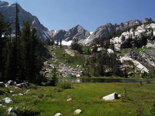
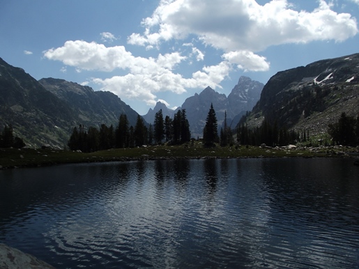
At roughly 10.6 miles the trail reaches the Lake Solitude area. Look for a short side trail that leads down to a small rocky peninsula jutting out into the lake. This is an outstanding spot to relax and soak-in the grand views. Lake Solitude is surrounded on almost three sides by a headwall that towers roughly 1500 feet above the lake. However, looking towards the south, Teewinot Mountain, Mt. Owen and Grand Teton seemingly rise above the western shore of the glacially-carved lake. This vantage point allows hikers to see the actual difference in size among the three mountains, which rank as the first, second and sixth highest peaks in the park.
After soaking in the views hikers will continue descending towards Cascade Canyon. Throughout this stretch hikers will enjoy great views of Mt. Owen and Grand Teton. Much of this section traverses over fairly rocky and rugged terrain, which can also remain at least partially snow-covered through June, or even into early July. However, once the snow melts, the surrounding meadows explode with a riot of wildflowers. Depending on snowpack, wildflowers are usually at their best during the late July and early August time periods. Keep an eye out for Indian paintbrush, Columbia monkshood, columbines, bluebells, purple fringed gentians and yellow goldenrod, among several other varieties. Depending on your timing, you may also find a profusion of glacier lilies surrounding the lake.
 At 13.3 miles hikers will reach the Forks of Cascade Canyon. The trail veering off towards the right leads towards Hurricane Pass and the Alaska Basin, while the trail to the left travels down Cascade Canyon. Hikers should turn left onto the Cascade Canyon Trail to continue the loop hike.
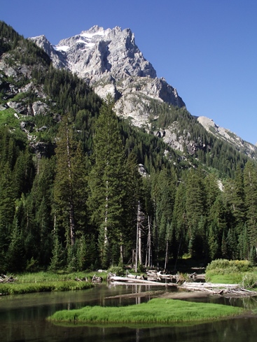
As you proceed down the canyon the trail passes through numerous huckleberry, thimbleberry and wild raspberry patches. While passing through these areas it's a good idea to make a lot of noise in case there are any bears around, especially near Cascade Canyon Creek where bears may not be able to hear you approaching. While black bears are frequently seen in Cascade Canyon, grizzly bears are becoming more common. Also keep an eye out for moose near the willow-choked portions of the creek. The views of Mt. Owen, the prominent mountain on the south side of the canyon, are absolutely stunning throughout this area, especially near the mouth of the canyon. At 12,928 feet Mt. Owen is the second highest mountain in Grand Teton National Park, and is named for William O. Owen, organizer of the first ascent of Grand Teton in 1898.
Hikers will eventually pass through the mouth of Cascade Canyon, and at roughly 16.8 miles from the trailhead, will reach the north horse path junction. Hikers should turn left here to continue the loop hike. Proceeding straight here will lead you to Inspiration Point.
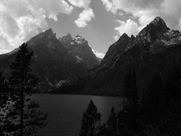 At roughly 17.5 miles hikers will reach the Jenny Lake Trail. You should turn left here as well. From this point the loop travels along the northwestern shore of Jenny Lake. Much of this portion of the route travels through open terrain, mainly due to the lightning-ignited Alder Fire, which scorched 391 acres in 1999. This side of the lake also offers great views of the Gros Ventre Mountains towards the east. This section of trail also passes through some fairly long stretches of thimbleberries. Hikers should keep an eye out for black bears throughout this portion of the hike.
At roughly 18.8 miles hikers will reach the String Lake Trail junction. You should proceed straight ahead to continue towards the Lake Leigh Trailhead. Soon you'll pass over the footbridge that crosses over the String Lake Outlet. After crossing the bridge you'll turn left and walk roughly one hundred yards to reach the String Lake Trailhead. You should continue heading north to reach the Leigh Lake Trailhead. Portions of this last section of trail will be paved, and will include a few interpretative signs along the way that explain the process of glaciation and how the chain of lakes were created below the Teton Range. Hikers will finally return to the Leigh Lake Trailhead at roughly 19.7 miles.